Graphic Representation

The above is a graphic representation of the potential for severe weather.

The Birmingham office of the National Weather Service has released the following statement:

THUNDERSTORMS CAPABLE OF PRODUCING DAMAGING WINDS AND LARGE HAILLOOK LIKELY ACROSS ALL OF CENTRAL ALABAMA ON THURSDAY…AND SOMECOULD PRODUCE TORNADOES. SEVERE THUNDERSTORMS WILL BE POSSIBLE ASEARLY AS 11 AM IN WESTERN ALABAMA AND LAST UNTIL JUST AFTER SUNSET ASSTORMS TRACK EASTWARD ACROSS THE STATE. THIS SYSTEM HAS THEPOTENTIAL TO BE A SIGNIFICANT SEVERE WEATHER EVENT BUT THERE IS STILLA BIT OF UNCERTAINTY. ADJUSTMENTS TO THE EXACT TIMING AND SEVERITY OFTHIS SYSTEM WILL LIKELY BE NEEDED.

Severe Weather Chance March 1st

Alabama looks to be under the gun again this coming Thursday for severe weather including tornados, hail, and severe thunderstorms. Like the event last week, this will probably not be a “super outbreak”, but parts of Mississippi, Central Alabama, and Eastern Georgia appear to have the most risk.

The NWS statement reads:

GFS AND NAM MODELS ARE A LITTLE DIFFERENT ON THE TIMING OF THINGSTHIS GO AROUND. THE GFS HAS SPED THINGS UP A BIT…WHICH GOESAGAINST WHAT USUALLY HAPPENS IN SITUATIONS LIKE THIS. I REALLYPREFER THE TIMING OF THE NAM…AND WILL USE IT AS THE BASIS FORTHE THURSDAY-THURSDAY NIGHT FORECAST. I FORESEE A SCENARIO OF RAINMOVING THROUGH LATE WEDNESDAY NIGHT INTO THURSDAY MORNING. THE RAINTAPERS OFF/SHIFTS NORTHEAST…AND THE LOW LEVEL WINDS REALLY KICK IN.SEVERE STORMS BREAK OUT NEAR THE MISSISSIPPI RIVER IN THE EARLYAFTERNOON…AND MOVE EAST INTO ALABAMA DURING THE EVENING. I WOULDNTBET ALL-IN ON A SQUALL LINE…EITHER…AS THERE SEEMS TO BE A GOODBALANCE BETWEEN SHEAR AND INSTABILITY TO SUPPORT SUPERCELLS. THESTORMS SHOULD THEN MOVE OUT THURSDAY EVENING OR EARLY FRIDAYMORNING.

I will update as more information becomes available.

Severe Weather Update

Today’s weather and tonight’s/tomorrow’s severe weather events have been well to our north, and at this point I expect that we here in the Gulf Shores area will not experience the brunt of this squall line, unlike Dumas which was hit hard earlier today with tornado damage.

While I would not go so far as to say that we are completely out of the woods on a severe weather as the line is marching onward with some storms moving at a whopping 75mph.

After this risk, the next potential appears to be manifesting around March 1, 2007.

Overnight tonight and into the morning, I would expect numerous tornado warnings for Mississippi and most of Alabama with the storms weakening towards the morning then perhaps re-intensifying as they move into/cross into Georgia.

As the system rumbles through Alabama, I will provide more updates.

Severe Weather on Feb 24th?

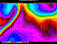
The dry line and associated front is pushing through northern TX, OK, and KS tonight, there have been several severe TS warnings issued, and at least 3 tornado warnings.

This system will move into our area tomorrow, bringing much of Alabama under the threat of severe weather tomorrow evening and into tomorrow night.
The NWS out of Birmingham has tendered the following discussion:

AREA FORECAST DISCUSSIONNATIONAL WEATHER SERVICE BIRMINGHAM AL1015 PM CST FRI FEB 23 2007
.UPDATE…FOR DISCUSSION.
DECIDED TO GO AHEAD AND HOIST A LAKE WIND ADVISORY FOR TOMORROW.WINDS WILL STEADILY INCREASE FROM THE SOUTHEAST AHEAD OF TOMORROWNIGHT`S MONSTER SYSTEM. AS FOR THE SYSTEM ITSELF AND IT`S AFFECTS ONUS…ALL INDICATIONS POINT TO SIGNIFICANT FRONTAL FORCING AS THEFRONT PUSHES THROUGH DURING THE OVERNIGHT HOURS TOMORROW NIGHT.EVERYTHING WILL BE SPINNING. IT WILL BE A LONG NIGHT.
BACK TO THE WIND LINE OF THOUGHT…THE WINDS WILL BE ABOVE LAKE WINDADVISORY CRITERIA THROUGH SUNDAY…BUT FOR NOW WILL RUN THE FIRSTADVISORY THROUGH 6 PM SATURDAY.
-=END BHAM WX STATEMENT=-

Please be advised that these evening and night storm systems are extremely dangerous as many of us are asleep upon arrival. This system poses a threat mainly to areas of Birmingham AL south to Gulf Shores area. Wind and hail appear to be the most significant threat at the time of this writing.

Please monitor your local broadcasts and have your NOAA weather radio ready. DISCLAIMER: This is an UNOFFICIAL forecast, for OFFICIAL information please refer to the National Weather Service office and bulletins issued out of regional offices and the Birmingham NWS center.

The product aboove is also agreed via the NWS office out of Memphis TN.

Tornados In Central Alabama

Tornados and severe storms ripped through Central Alabama late yesterday afternoon. For the most part, property damage was minor. Once the first line of storms passed early in the morning, the Gulf Shores area saw nothing but sunshine and clear skies.

That was not the case between Birmingham and Montgomery as virtually all of the counties along I-65 at one point or another had a Tornado Warning issued for them. Fortunately, at the time of this writing, I have not had any reports of any serious injuries or fatalities.

This is the same system that damaged or destroyed several hundred homes in New Orleans and killed one person, injuring several others. While the damage was nowhere near the scale of a Katrina or Ivan, for the people in the path of these storms, the difference is moot.

New Content and Resources

This year brings some exciting technical changes as we will be adding new content resources to get the information we all need out as rapidly and efficiently as possible. Among the items we are working on:

Distribution to multiple media outlets as a storm threatens

  • Regular content feeds
  • On-site video from our spotters
  • Comprehensive resources
  • Additional researchers and responders

Now, with all that out of the way, on to the weather. The past month has seen a couple of localized tornadic outbreaks, each with fatalities, and there remains an immediate threat for the SouthEast on Tuesday, February 13, 2007. People along the Gulf Coast and as far north as Birmingham, Alabama should closely monitor the weather tomorrow.

While the potential for isolated severe weather exists, I do not feel that we are staring down the barrel of a “super outbreak” of tornados. I do, however, think we will have a more active spring severe weather cycle than we had last year.

As always, we will monitor this information and present our findings.