Named Storm Lorenzo 2013

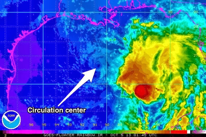
Tropical Storm Lorenzo formed in the central Atlantic from a tropical depression earlier today. This storm will move to the north and then to the northeast, well away from any US coastal areas. For that reason, this will be our only mention of Tropical Storm Lorenzo.

For up to the minute official advisories and information, please visit the NHC website in Miami:

http://www.nhc.noaa.gov/

=============================================

“THIS IS NOT AN OFFICIAL ADVISORY. These updates and advisories are based upon information from our own computer models, NOAA, Local Weather Data Centers, deep water Buoy Data, and other publicly available sources. FOR THE SAFETY OF YOUR PROPERTY AND PERSON, please refer to your Local, State, and Federal Authority updates for Official Advisories and Orders. For up to the minute advisories and official updates, it is essential that you monitor your local Emergency Government, NOAA and Local Media Broadcasts. Please do not make personal safety decisions based upon information presented here in this Unofficial Advisory.”

Tropical Storm Research Center, Gulf Shores, Alabama.

http://www.wootaah.blogspot.com/

============================================

Final Named Storm Karen Update – 05 October 2013, 05:00 AM CDT

Final Named Storm Karen Update 05 October 2013 – 05:00 AM CDT

Tropical Storm Karen underwent some changes over the past 30 hours. The strong Jet Stream upper level wind flow has taken the top of the storm apart and has prevented development. This was looked at as a possibility 5 days ago by our TSRC team and this is what actually took place. There will be gusty winds, elevated surf and rip currents, and heavy rains in places along the northern Gulf Coast and along the Florida Gulf Coast for up to 3 days, but this system is weakening and will not pose a significant threat. As a result of current conditions, this will be our final Named Storm Karen unofficial update. However, persons from Northern Florida through the Northeastern Maryland region should anticipate the remnants of Karen this coming week.

For up to the minute official advisories and information, please visit the NHC website in Miami:

http://www.nhc.noaa.gov/

We are also providing the temporary government link to the active watch and warning website:

http://www.weather.gov/

Click on the area of the map closest to your residence for up to the minute local information

=============================================

“THIS IS NOT AN OFFICIAL ADVISORY. These updates and advisories are based upon information from our own computer models, NOAA, Local Weather Data Centers, deep water Buoy Data, and other publicly available sources. FOR THE SAFETY OF YOUR PROPERTY AND PERSON, please refer to your Local, State, and Federal Authority updates for Official Advisories and Orders. For up to the minute advisories and official updates, it is essential that you monitor your local Emergency Government, NOAA and Local Media Broadcasts. Please do not make personal safety decisions based upon information presented here in this Unofficial Advisory.”

Tropical Storm Research Center, Gulf Shores, Alabama.

http://www.wootaah.blogspot.com/

============================================

Tropical Storm Karen has been “decapitated”.

KAREN HAS BEEN DECAPITATED BY STRONG SOUTHWESTERLY SHEAR AND NOW
CONSISTS OF A VERY TIGHT SWIRL OF LOW CLOUDS WITH SOME LINEAR
CONVECTION TO THE EAST OF THE CENTER.

That was the wording in one of the discussions from the National Hurricane Center.  High wind shear and dry air flowing into the western side of the storm have all but removed activity from the center of circulation.

This year has been different, but in a good way, as virtually every named storm has been shredded by dry air or shear, and in this case, both.  Of course, coastal surge, localized flooding, and inland storms with isolated tornadoes remain a concern, but a central “direct hit” from a tropical system appears unlikely.  Essentially, this system is D.O.A., which is a good thing.

We are monitoring a couple of other possible events and will post information as needed.  Be advised, that the remnants of Karen will bring heavy rain, gusty winds, and some potential for isolated tornadoes as the cold front sweeps them up, possibly in North-Central Alabama, Georgia, and South Carolina.

We will continue to monitor “Karen” but I expect our final advisory will be issued in the morning.

Tropical Storm Karen Update – 04 October 2013, 3:40 AM CDT

Tropical Storm Karen Update – 04 October 2013, 03:40 AM CDT.

As we anticipated yesterday, the dry air to the northwest of the storm is preventing rapid development. It will be a fairly strong Tropical Storm but almost all of the thunderstorm activity is to the east of the center of the low pressure core – it will most likely not have a fully developed circulation.  Gusty winds, heavy rain, high surf and a few tornadoes will be present for the region. Tropical Storm Karen will be making center core landfall near Mobile Bay, Alabama, late Saturday evening, October 05, however, this is a fairly elongated storm, so the general effects will be felt from New Orleans, Louisiana, to Apalachicola, Florida.

All persons in this coastal area should be monitoring  local media broadcasts as well as official advisories from your local Emergency Operations Centers.

For up to the minute official advisories and information, please visit the NHC website in Miami:

http://www.nhc.noaa.gov/

We are also providing the temporary government link to the active watch and warning website:

http://www.weather.gov/

Click on the area of the map closest to your residence for up to the minute local information

=============================================

“THIS IS NOT AN OFFICIAL ADVISORY. These updates and advisories are based upon information from our own computer models, NOAA, Local Weather Data Centers, deep water Buoy Data, and other publicly available sources. FOR THE SAFETY OF YOUR PROPERTY AND PERSON, please refer to your Local, State, and Federal Authority updates for Official Advisories and Orders. For up to the minute advisories and official updates, it is essential that you monitor your local Emergency Government, NOAA and Local Media Broadcasts. Please do not make personal safety decisions based upon information presented here in this Unofficial Advisory.”

Tropical Storm Research Center, Gulf Shores, Alabama.

http://www.wootaah.blogspot.com/

============================================

ALERT !! Named Storm Karen 2013

Tropical Storm Karen is the strengthening storm that we mentioned earlier this week in another post. This storm is being treated as a potential worst case scenario by many forecasters due to the fairly short time period left before landfall. Therefore, we are advising all Gulf Coast residents from the Louisiana – Texas border over to Apalachicola, Florida, to have your storm preparations in order immediately. Due to rapidly changing conditions, this storm will most likely reach Hurricane Category 1 status late Friday but may weaken some before landfall. However, a strong Tropical Storm can inflict wind, water and storm surge damage. All persons in the Gulf Coast area mentioned should monitor local official advisories and take all necessary precautions as this storm moves to the north.

For up to the minute official advisories and information, please visit the NHC website in Miami:

http://www.nhc.noaa.gov/

=============================================

“THIS IS NOT AN OFFICIAL ADVISORY. These updates and advisories are based upon information from our own computer models, NOAA, Local Weather Data Centers, deep water Buoy Data, and other publicly available sources. FOR THE SAFETY OF YOUR PROPERTY AND PERSON, please refer to your Local, State, and Federal Authority updates for Official Advisories and Orders. For up to the minute advisories and official updates, it is essential that you monitor your local Emergency Government, NOAA and Local Media Broadcasts. Please do not make personal safety decisions based upon information presented here in this Unofficial Advisory.”

Tropical Storm Research Center, Gulf Shores, Alabama.

http://www.wootaah.blogspot.com/

============================================