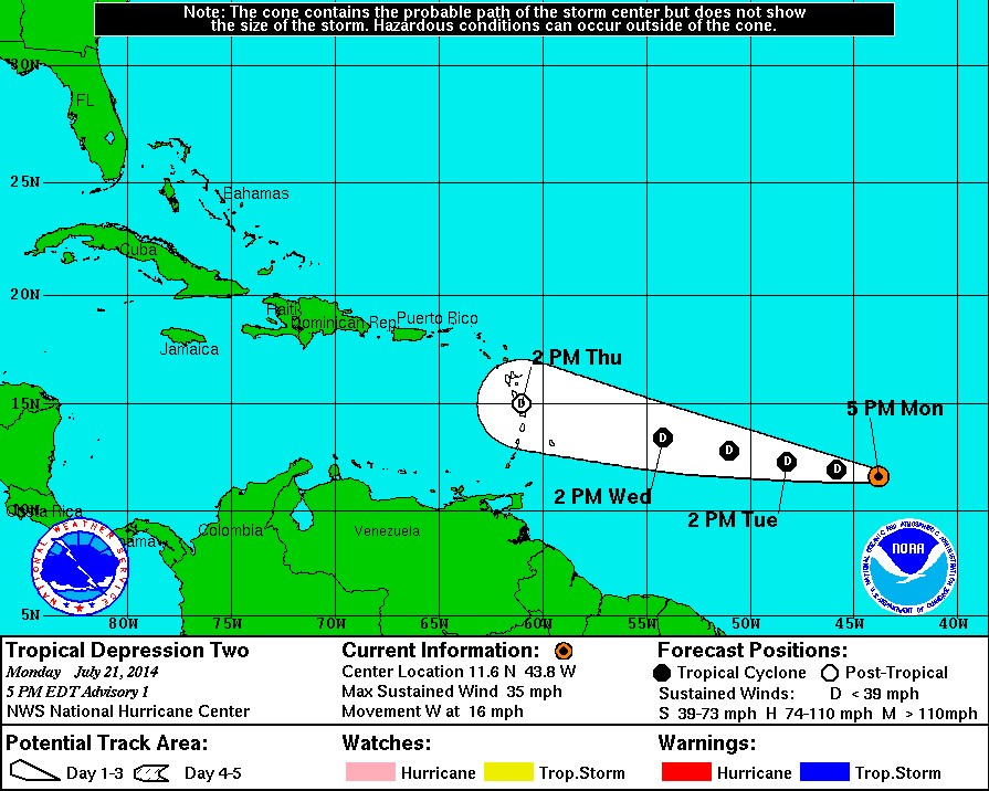
TD 2 has formed in the central Atlantic, and is about 1,200 miles east of the Leeward Islands, moving west. We will continue to monitor this system and provide updates as needed.

Tropical information for the Coast, by the Coast,
TD 2 has formed in the central Atlantic, and is about 1,200 miles east of the Leeward Islands, moving west. We will continue to monitor this system and provide updates as needed.
The Atlantic Basin remains quiet. The NHC is monitoring the possibility of a “spin up” much like a couple of weeks ago. Such a scenario would impact the eastern seaboard, and pose no threat to the Gulf of Mexico. We remain in our typical July pattern: Afternoon thundershowers, and temperatures in the high 80’s to low 90’s.
Our tracking is looking towards August as some of our modeling solutions suggest less “SAL” interference of the coast of Africa and more stable conditions across the warming waters of the Atlantic.
The midwest and most parts as far south as North Carolina may see lows under and up to the mid 40’s over the course of the week. An Upper Level Low system will bring in some cooler air to many parts of the Eastern U.S. Severe weather outbreaks are not anticipated. Simply expect a few chilly mornings.
Hurricane Arthur Update 04 July 2014 05:45 AM.
As projected in a previous post, Hurricane Arthur came ashore as a Category 2 storm initially just southeast of Beaufort, North Carolina, around 12:00 AM and crossed over the Outer Banks at approximately 3:30 AM. The storm is now over open water in the Atlantic again and is moving to the northeast at nearly 25 MPH. Peak winds are still in excess of 110 MPH but will slowly diminish over the next 24 hours.
Persons from Coastal Virginia to New England can expect heavy rain, gusty winds, high surf, rip currents, beach errosion, some low category tornadoes and areas of lowland flooding over the next 12 to 24 hours.
This will be our final Hurricane Arthur info post. However, please use the information below if you have concerns about conditions for your own area.
Please use the NHC link below for official advisories:
We are also supplying a link to the NWS US Interactive Storm Map:
http://www.nws.noaa.gov/largemap.php
======================================================================================
“These are not official advisories. These updates and advisories are based upon information from our own computer models, NOAA, Local Weather Data Centers, deep water Buoy Data, and other publicly available sources. FOR THE SAFETY OF YOUR PROPERTY AND PERSON, please refer to your Local, State, and Federal Authority updates for Official Advisories and Orders. For up to the minute advisories and official updates, it is essential that you monitor your local Emergency Government, NOAA and Local Media Broadcasts. Please do not make personal safety decisions based upon information presented here.”
Tropical Storm Research Center, Gulf Shores, Alabama.
======================================================================================
‘Arthur’ was upgraded to Hurricane Category 1 status overnight. The storm is strengthening and at this hour, is located off the South Carolina Coast moving northward at just under 10 mph. Mandatory evacuation orders are in effect for the outer banks and Cape Hatteras, North Carolina. Vacationers and locals are being advised to go inland to I-95 as soon as possible and before ferry service and bridges are forced to close. Persons from the Georgia – South Carolina border up to New England should be alert for changing conditions.
11:00 AM 03 July Update: The storm track of Hurricane Arthur has moved slightly westward since our 5 AM advisory. The sustained winds are over 90 mph near the eye wall core and this is expected to increase more. Landfall will be in North Carolina in the very early hours of Friday Morning, July 04 just after high tide. This will create a storm surge in excess of 6 feet in places to the north of the storm. Additionally, after landfall and the return of Arthur into the Atlantic, the storm related winds going on-shore from Virginia to New England will be substantial. Persons from the South – North Carolina border to Maine should be monitoring local NOAA and media information.
Please use the NHC link below for official advisories:
We are also supplying a link to the NWS US Interactive Storm Map:
http://www.nws.noaa.gov/largemap.php
============================================================
“These are not official advisories. These updates and advisories are based upon information from our own computer models, NOAA, Local Weather Data Centers, deep water Buoy Data, and other publicly available sources. FOR THE SAFETY OF YOUR PROPERTY AND PERSON, please refer to your Local, State, and Federal Authority updates for Official Advisories and Orders. For up to the minute advisories and official updates, it is essential that you monitor your local Emergency Government, NOAA and Local Media Broadcasts. Please do not make personal safety decisions based upon information presented here.”
Tropical Storm Research Center, Gulf Shores, Alabama.
===========================================================
As anticipated, the National Hurricane Center upgraded Tropical Depression # 1 to Tropical Storm Status. This storm is over relatively warm water near the coastal Gulf Stream and will intensify to high Tropical Storm force or Hurricane Category 1 within 12 to 36 hours. The storm track will be just off the east coast of the US extending from northeastern Florida to New England over the next 3 to 7 days.
Persons in coastal areas from Northeastern Florida to coastal Maine should be watching local media broadcasts for official information. However, many areas along the east coast can expect high surf, rip currents, heavy rain with lowlands flooding, some tornadoes, gusty winds and some beach errosion from a low to moderate storm surge..
Please use the NHC link below for official advisories:
We are also supplying a link to the NWS US Interactive Storm Map:
http://www.nws.noaa.gov/largemap.php
============================================================
“These are not official advisories. These updates and advisories are based upon information from our own computer models, NOAA, Local Weather Data Centers, deep water Buoy Data, and other publicly available sources. FOR THE SAFETY OF YOUR PROPERTY AND PERSON, please refer to your Local, State, and Federal Authority updates for Official Advisories and Orders. For up to the minute advisories and official updates, it is essential that you monitor your local Emergency Government, NOAA and Local Media Broadcasts. Please do not make personal safety decisions based upon information presented here.”
Tropical Storm Research Center, Gulf Shores, Alabama.
===========================================================
The National Hurricane Center in Miami has designated Tropical Depression # 1 out of a strong low pressure area off the Florida Coast near Miami. We are anticipating that this will become Named Storm Arthur within the next day.
Computer modeling is showing this storm starting to follow the Eastern Coast of Florida to the north-northeast in a matter of hours. As it does, it will intensify and most likely become the first Hurricane of the 2014 season as it follows the East Coast of the US from Florida up to New England over the next 4 to 7 days. We will post unofficial updates as this storm progresses. Please use the NHC link below for official advisories:
We are also supplying a link to the NWS US Interactive Storm Map:
http://www.nws.noaa.gov/largemap.php
======================================================================================
“These are not official advisories. These updates and advisories are based upon information from our own computer models, NOAA, Local Weather Data Centers, deep water Buoy Data, and other publicly available sources. FOR THE SAFETY OF YOUR PROPERTY AND PERSON, please refer to your Local, State, and Federal Authority updates for Official Advisories and Orders. For up to the minute advisories and official updates, it is essential that you monitor your local Emergency Government, NOAA and Local Media Broadcasts. Please do not make personal safety decisions based upon information presented here.”
Tropical Storm Research Center, Gulf Shores, Alabama.
======================================================================================