Late Season Data – October 01, 2017 –

The 2017 season has seen some extremely destructive storms which have caused many deaths.   While things are relatively quiet at the moment, the season is not over until November 30.  The volunteer staff at the Tropical Storm Research Center is monitoring all historical storm formation areas and we will publish our unofficial advisories as they become necessary.

For now, please use the link below to the National Hurricane Center in Miami, for official information on all named tropical origin storms.

http://www.nhc.noaa.gov/       

================================================

“These are not official advisories. These updates and advisories are based upon information from our own computer models, NOAA, Local Weather Data Centers, deep water Buoy Data, and other publicly available sources. FOR THE SAFETY OF YOUR PROPERTY AND PERSON, please refer to your Local, State, and Federal Authority updates for Official Advisories and Orders. For up to the minute advisories and official updates, it is essential that you monitor your local Emergency Government, NOAA and Local Media Broadcasts. Please do not make personal safety decisions based upon information presented here.”

https://gulfstorm.net

Tropical Storm Research Center, Gulf Shores, Alabama

===========================================

Hurricane Maria Update, September 19, 2017 @ 8 AM EDT

Hurricane Maria Update September 19, 2017 @ 8 AM EDT.

Hurricane Maria is currently a Category 5 storm with central core winds measured at just over 160 MPH. This deadly hurricane is making it’s way west northwest and is affecting the islands of the Lesser Antilles and will be making a direct impact on Puerto Rico late Tuesday and into Wednesday and most of Hispaniola on Thursday. This storm is projected to move into the southern Bahamas by Friday and will most likely start a northerly turn. There are some variables that could influence the track of Maria from Friday through early next week. Therefore, we are requesting that all persons living along the entire East Coast of the US from Florida to New England monitor this storm’s progress carefully. Use the link below for the National Hurricane Center for official information on all named tropical origin storms.

http://www.nhc.noaa.gov/

================================================

“These are not official advisories. These updates and advisories are based upon information from our own computer models, NOAA, Local Weather Data Centers, deep water Buoy Data, and other publicly available sources. FOR THE SAFETY OF YOUR PROPERTY AND PERSON, please refer to your Local, State, and Federal Authority updates for Official Advisories and Orders. For up to the minute advisories and official updates, it is essential that you monitor your local Emergency Government, NOAA and Local Media Broadcasts. Please do not make personal safety decisions based upon information presented here.”

https://gulfstorm.net

Tropical Storm Research Center, Gulf Shores, Alabama

===========================================

Named Storm Maria – 2017

Named Storm Maria is approximately 400 miles east southeast of the Lesser Antilles, moving westerly, and will reach hurricane strength within 24 hours. This storm is taking a nearly identical track to what Hurricane Irma took two weeks ago. This storm will reach Major Hurricane Strength by mid week as it gets into warmer waters of the northern Caribbean. Named Storm Maria will be affecting the same areas of the western Atlantic and Caribbean as Hurricane Irma did recently, causing more damage and destruction. While it is still too early to predict a storm track past the middle of this coming week, we are requesting that all persons with interests in Florida, the Gulf of Mexico and the Atlantic Coast of the US monitor the progress of Named Storm Maria and be prepared.

Please use the link below to the NHC for official information on all active Tropical Systems.

http://www.nhc.noaa.gov/

================================================

“These are not official advisories. These updates and advisories are based upon information from our own computer models, NOAA, Local Weather Data Centers, deep water Buoy Data, and other publicly available sources. FOR THE SAFETY OF YOUR PROPERTY AND PERSON, please refer to your Local, State, and Federal Authority updates for Official Advisories and Orders. For up to the minute advisories and official updates, it is essential that you monitor your local Emergency Government, NOAA and Local Media Broadcasts. Please do not make personal safety decisions based upon information presented here.”

https://gulfstorm.net

Tropical Storm Research Center, Gulf Shores, Alabama

===========================================

Named Storm Lee – AND New Tropical Depression 15 -2017

Named Storm Lee formed out of Tropical Depression 14 and is currently in the east central Atlantic near where Hurricane Irma formed two weeks ago.  There are unfavorable conditions ahead of Named Storm Lee and it is projected to move northwest and reduce in intensity over the next week.  Unless Name Storm Lee starts to take a more westerly track, this will be our only mention of this storm.

A NEW area of concern is Tropical Depression 15 which MAY become named storm Maria within 24 hours.  This Depression is about 700 miles east southeast of the Lesser Antilles and will be going into favorable conditions for development. Projections are that Tropical Depression 15, may become a Tropical Storm and then a Hurricane and travel into the northern Caribbean near the old track of Hurricane Irma.  We will start a separate unofficial advisory if Tropical Depression 15 eventually elevates to Hurricane status. There is a possibility that this system will follow the same track as Irma through the northern Caribbean Islands.

Please use the link below to the NHC for official information on all active Tropical Systems.

 
================================================
 
“These are not official advisories. These updates and advisories are based upon information from our own computer models, NOAA, Local Weather Data Centers, deep water Buoy Data, and other publicly available sources. FOR THE SAFETY OF YOUR PROPERTY AND PERSON, please refer to your Local, State, and Federal Authority updates for Official Advisories and Orders. For up to the minute advisories and official updates, it is essential that you monitor your local Emergency Government, NOAA and Local Media Broadcasts. Please do not make personal safety decisions based upon information presented here.”
 
 
Tropical Storm Research Center, Gulf Shores, Alabama
 
===========================================

Important: Named Storm Jose Update, September 15, 2017 @ 6AM EDT

Named Storm Jose has been nearly stationary in the central Atlantic for nearly a week. However, the National Hurricane Center in Miami has gathered tracking projections from international sources and in their recent advisory update, they are suggesting a more westerly track than what was being mentioned earlier. There is a possibility that Named Storm Jose may be affecting the US Atlantic Coastal areas early this coming week, anywhere from the outer banks of North Carolina and Virginia border up through most of Coastal New England. It is for that reason that we are recommending that all persons in this wide area of the US Atlantic Coast monitor official advisories from the National Hurricane Center in the link below and have all storm preparations and planning in place very soon.

 
================================================
 
“These are not official advisories. These updates and advisories are based upon information from our own computer models, NOAA, Local Weather Data Centers, deep water Buoy Data, and other publicly available sources. FOR THE SAFETY OF YOUR PROPERTY AND PERSON, please refer to your Local, State, and Federal Authority updates for Official Advisories and Orders. For up to the minute advisories and official updates, it is essential that you monitor your local Emergency Government, NOAA and Local Media Broadcasts. Please do not make personal safety decisions based upon information presented here.”
 
 
Tropical Storm Research Center, Gulf Shores, Alabama
 
===========================================

Named Storm Jose – 2017

Hurricane Jose formed from a Tropical Depression in the eastern Atlantic over a week ago. We have delayed our mention of this storm until now because of the seriousness of Hurricane Irma.
 
Hurricane Jose is parked in the west central Atlantic and has very little in the way of steering currents to move it. It will hover near it’s position for several days until it interacts with other weather systems. For now, we will not report further on Named Storm Jose until such time as it starts moving in any predictable direction.
 
In the mean time, please use the NHC link below for details on all active named storms including the progress of Irma.
 
 
================================================
 
“These are not official advisories. These updates and advisories are based upon information from our own computer models, NOAA, Local Weather Data Centers, deep water Buoy Data, and other publicly available sources. FOR THE SAFETY OF YOUR PROPERTY AND PERSON, please refer to your Local, State, and Federal Authority updates for Official Advisories and Orders. For up to the minute advisories and official updates, it is essential that you monitor your local Emergency Government, NOAA and Local Media Broadcasts. Please do not make personal safety decisions based upon information presented here.”
 
 
Tropical Storm Research Center, Gulf Shores, Alabama
 
===========================================

Deadly Hurricane Irma – Unofficial Update September 8, 2017

DEADLY HURRICANE IRMA Unofficial Update September 8, 2017:

Hurricane Irma is still a very high Category 4 storm.  Most worldwide tracking models are showing a landfall in the Florida Keys and into mainland south Florida Saturday evening through Sunday morning.  The width of the Hurricane Force Winds is roughly 140 miles in diameter – wider than the state of Florida. Wind gusts to 150 MPH will be common through southern and parts of central Florida.  Storm surges of 8 to 14 feet are anticipated on both coasts of Florida with 20 to 30 foot waves ON TOP of the storm surge. Rain totals could exceed 12 inches from southern Florida to Tennessee and the Carolinas.

We are REQUESTING that all persons who reside in MANDATORY EVACUATION ZONES do so NOW.  Your life may depend on it.

For official updates, please use the link below to the National Hurricane Center in Miami.

==================================================
“These are not official advisories. These updates and advisories are based upon information from our own computer models, NOAA, Local Weather Data Centers, deep water Buoy Data, and other publicly available sources. FOR THE SAFETY OF YOUR PROPERTY AND PERSON, please refer to your Local, State, and Federal Authority updates for Official Advisories and Orders. For up to the minute advisories and official updates, it is essential that you monitor your local Emergency Government, NOAA and Local Media Broadcasts. Please do not make personal safety decisions based upon information presented here.”
Tropical Storm Research Center, Gulf Shores, Alabama
===========================================

Very Dangerous Situation

The westwardly track that we have been monitoring continues.  We have been looking at the High and the Low (Cold Front), coming across the south eastern regions.  In short, our models trend westward.  We do expect a shift north but perhaps not as soon as popular media depicts.

TAKE ACTION NOW  

We can not stress how dangerous this storm system is.  With sustained 185 mile per hour winds, and shoving up to 20 feet of water over the coast.  We can add inland storms, lightning, tornados.  If you are in a low lying or coastal area...  LEAVE NOW.  ALL OTHERS, TAKE STEPS TO SECURE  YOURSELVES AND YOUR PROPERTY.  Houses can be re-built. 

Along the Northern Gulf Coast, there could be impacts as well.

UPDATE: – September 5, 2017 – Major Hurricane Irma

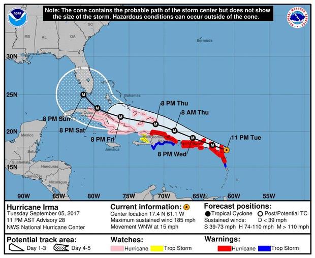
UPDATE: HURRICANE IRMA  has strengthened to Category 5 with core winds at over 176 MPH and gusting close to 200 MPH.

Official tracking agencies and our own modeling are in general agreement that Major Category Hurricane Irma will continue it’s westerly track, causing severe issues along its’ track. This Hurricane will approach the Florida Straits by this Saturday, September 9. Official tracking  models and projections from the National Hurricane Center are showing a northerly turn sometime on Saturday, September 9 and into Sunday, September 10.  Due to this track projection by official agencies, we are now requesting that ALL PERSONS who live in Florida, Georgia, Alabama, Mississippi, Louisiana, South Carolina, North Carolina and east Texas give this dangerous storm your full attention.  There are some variables that may affect the final track of this storm, so EVERYONE in Florida, the Southeastern States and the Gulf Coast States should be making preparations for some level of effects from a Major Category Hurricane starting as early as Friday, September 8 and extending through late next week.

For official updates, please use the link below to the National Hurricane Center in Miami.

==================================================
“These are not official advisories. These updates and advisories are based upon information from our own computer models, NOAA, Local Weather Data Centers, deep water Buoy Data, and other publicly available sources. FOR THE SAFETY OF YOUR PROPERTY AND PERSON, please refer to your Local, State, and Federal Authority updates for Official Advisories and Orders. For up to the minute advisories and official updates, it is essential that you monitor your local Emergency Government, NOAA and Local Media Broadcasts. Please do not make personal safety decisions based upon information presented here.”
Tropical Storm Research Center, Gulf Shores, Alabama
NOTE: In keeping with our policy of reporting on all named storms, Named Storm Jose is in the east central Atlantic following along behind Hurricane Irma in a generally westerly direction. Named Storm Jose will not be reported on until Hurricane Irma coverage is completed.
NOTE: In keeping with our policy of reporting on all named storms, Named Storm Katia, located in the southwestern Gulf of Mexico, will not be affecting the US. This will be our only mention of Named Storm Katia.
PLEASE review the information provided in the main Post above.
 
 ===========================================

UPDATE: September 03 – Named Storm Irma – 2017

Named Storm Irma has strengthened to a Category 3  Hurricane. It is currently 900 miles east of the Leeward Islands  and is moving generally westerly.  As this storm gets closer to the Lesser Antilles, it will start to be over very warm water and will intensify even more.  Tracking models are still inaccurate for 5 days out, however we are requesting that all persons who live along the Gulf Coast and US Atlantic  Coast from southern Florida to New England CAREFULLY monitor the progress of this dangerous hurricane and prepare. We will post additional unofficial information as it becomes available.

For official updates, please use the link below to the National Hurricane Center in Miami.

==================================================
“These are not official advisories. These updates and advisories are based upon information from our own computer models, NOAA, Local Weather Data Centers, deep water Buoy Data, and other publicly available sources. FOR THE SAFETY OF YOUR PROPERTY AND PERSON, please refer to your Local, State, and Federal Authority updates for Official Advisories and Orders. For up to the minute advisories and official updates, it is essential that you monitor your local Emergency Government, NOAA and Local Media Broadcasts. Please do not make personal safety decisions based upon information presented here.”
Tropical Storm Research Center, Gulf Shores, Alabama
===========================================