Major Hurricane Laura Information, post landfall.

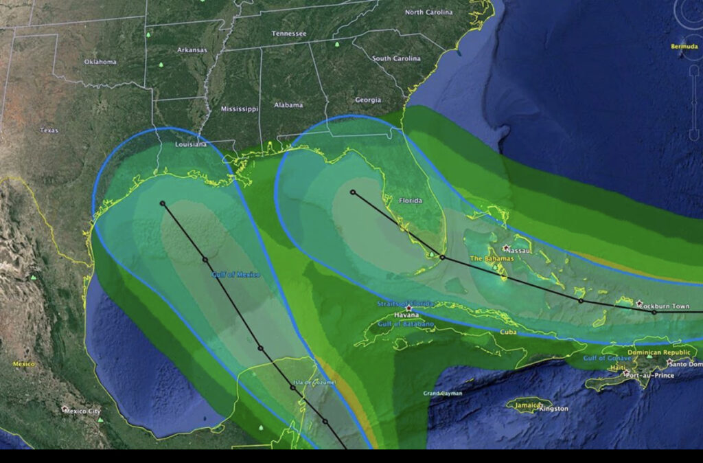
Major Hurricane Laura made landfall south of Lake Charles, Louisiana, early August 27 as a Category 4 storm with sustained winds in the eyewall at over 152 MPH. Storm surge to the northeast of the eye was between 15 and 21 feet with wave action on top of that, causing catastrophic coastal damage in southwest Louisiana. This storm is moving inland and will be affecting Arkansas, Tennessee, Kentucky, West Virginia, Virginia and the mid Atlantic states over the next few days. This storm will carry tropical storm force winds inland and will dump substantial rain with some flooding, gusty winds and some tornadoes through the weekend along it’s track. The death toll is climbing and damage reports are starting to come in.

Refer to Local, State and National news media and the National Weather Service for additional details.

https://www.weather.gov/

===============================================

“These are not official advisories. These updates and advisories are based upon information from our own computer models, NOAA, Local Weather Data Centers, deep water Buoy Data, and other publicly available sources. FOR THE SAFETY OF YOUR PROPERTY AND PERSON, please refer to your Local, State, and Federal Authority updates for Official Advisories and Orders. For up to the minute advisories and official updates, it is essential that you monitor your local Emergency Government, NOAA and Local Media Broadcasts. Please do not make personal safety decisions based upon information presented here.”

www.gulfstorm.net​​​

Tropical Storm Research Center, Gulf Shores, Alabama

=============================================

Named Storm Laura intensifies as Marco weakens.

Tropical Storm Marco weakened to a low pressure area just south of Morgan City,  Louisiana, as TS Laura is forecast to become a Major (Cat 3 or above) Hurricane before making landfall in the same approximate area as Marco late Wednesday night or very early Thursday morning. With most of the wind and storm surge to the northeast of Hurricanes, persons in southeastern Louisiana can expect Hurricane conditions while persons in southern Mississippi, southern Alabama and the far northwestern part of Florida can expect  limited Tropical Storm conditions (high waves, gusty winds and heavy rain from early Wednesday through later in the day Thursday.)  Lowland flooding may take place in these locations. Areas closer to the center of Laura, as it moves inland a few hundred miles, may be placed under regional flash flood watches through the weekend. Persons from Houston, Texas, to Mobile, Alabama, should monitor your local Emergency Management Offices for official news and orders.

UPDATE: August 26, 2020 @ 5:45 AM EDT –

Many international tracking models are showing “Laura” as a Category 4 storm late Wednesday night before it makes landfall near the Texas/Louisiana border.   That’s  130 to 156 MPH SUSTAINED wind with gusting to nearly 170 MPH near the eyewall.  That will bring a vertical storm surge of up to 15 feet with 22 to 30 foot waves on top of the surge – just to the northeast of the center.  Worst case scenario – a wall of waves 45 feet above normal Gulf level being pushed inland nearly 3 miles.  Lake Charles, Louisiana, may be in the bullseye.   Even the area just to the south of New Orleans may see a water rise of 4 to 6 feet with 11 to 15 foot waves on top of that.  The New Orleans levee system averages 21 feet high in most places.


Please visit the National Hurricane Center website for official news and advisories. 
https://www.nhc.noaa.gov/


=============================================== 
“These are not official advisories. These updates and advisories are based upon information from our own computer models, NOAA, Local Weather Data Centers, deep water Buoy Data, and other publicly available sources. FOR THE SAFETY OF YOUR PROPERTY AND PERSON, please refer to your Local, State, and Federal Authority updates for Official Advisories and Orders. For up to the minute advisories and official updates, it is essential that you monitor your local Emergency Government, NOAA and Local Media Broadcasts. Please do not make personal safety decisions based upon information presented here.”


www.gulfstorm.net


Tropical Storm Research Center, Gulf Shores, Alabama
=============================================

Tropical Storms Laura and Marco – 2020 converging in the Gulf of Mexico.

As Tropical Storms Laura and Marco make their way into the Gulf of Mexico, persons along the tracks of these storms should be monitoring conditions carefully.

Having two such storms in the Gulf at the same time is extremely rare and official tracking models from international agencies are not as accurate as if only one storm was on the move. The interaction between two storms in the Gulf at the same time is unpredictable.

Our suggestion for all persons living along the entire US Gulf Coast is to make preparations for possible hurricane conditions late Monday, August 24, through late Thursday, August 27.

Please visit the National Hurricane Center website for official news and advisories.

National Hurricane Center

===============================================

“These are not official advisories. These updates and advisories are based upon information from our own computer models, NOAA, Local Weather Data Centers, deep water Buoy Data, and other publicly available sources. FOR THE SAFETY OF YOUR PROPERTY AND PERSON, please refer to your Local, State, and Federal Authority updates for Official Advisories and Orders. For up to the minute advisories and official updates, it is essential that you monitor your local Emergency Government, NOAA and Local Media Broadcasts. Please do not make personal safety decisions based upon information presented here.”

www.gulfstorm.net

Tropical Storm Research Center, Gulf Shores, Alabama


=============================================

Potential Fujiwhara Effect – TD 13 and TD 14 – 8/2020

First and foremost, the image represented above is a graphic example of a potential situation that could exist in the Gulf of Mexico over the next several days. It is not a forecast graphic or model, it is just an illustration of one of many possible scenarios. Additionally, Gulfstorm.net does not typically post about Tropical Depressions. In this instance, there is a chance for a rare phenomenon called the Fujiwhara Effect to occur in the GoM. The event is named after the Japanese scientist Sakuhei Fujiwhara who discovered the effect in 1921.

In the phenomenon, when two tropical systems get close to each other, they will begin to interact with one another. At a distance of around 900 miles, they will begin orbiting one another, much as the moon orbits the Earth. In that case, they are competing for the same resources, which limits each low pressure system’s ability to significantly strengthen. If one of the storms is “stronger” than the other, and their centers of circulation are around 200 miles from one another, the “stronger” system will absorb the other system, which would most likely result in a RIC (Rapid Intensification Cycle). Simply put the stronger storm would get even stronger.

We will continue to monitor these systems and provide updates as more data comes in.

Tropical Depression Thirteen / Named Storm Laura- 2020

Tropical Depression Thirteen/ Named Storm Laura formed in the Central Atlantic from a tropical low pressure area. This storm system is moving west northwest at roughly 20 mph and has potential for further development over the next couple of days as it passes near Puerto Rico on Saturday and and the southern Bahamas on Sunday. Most tracking agencies are showing gradual strengthening as this storm moves toward south Florida Monday and Tuesday from it’s current location. Persons along the Southeastern US and Gulf Coast should be monitoring the progress of this storm and should be making preparations as directed by local emergency management agencies and the National Hurricane Center in Miami.

Update Aug. 19, 2020 @ 8:30 PM EDT: We are also watching Tropical Depression Fourteen in the western Caribbean. International tracking models are indicating a Texas/Louisiana involvement early this coming week. Intensity projections are not precise right now because there have not been two active storm areas in the Gulf at the same time since 1955 and interaction between these two storm areas is not very predictable.

Please visit the National Hurricane Center website for official news and advisories.

https://www.nhc.noaa.gov/

===============================================
“These are not official advisories. These updates and advisories are based upon information from our own computer models, NOAA, Local Weather Data Centers, deep water Buoy Data, and other publicly available sources. FOR THE SAFETY OF YOUR PROPERTY AND PERSON, please refer to your Local, State, and Federal Authority updates for Official Advisories and Orders. For up to the minute advisories and official updates, it is essential that you monitor your local Emergency Government, NOAA and Local Media Broadcasts. Please do not make personal safety decisions based upon information presented here.”

https://gulfstorm.net


Tropical Storm Research Center, Gulf Shores, Alabama

=============================================

Named Storm Kyle – 2020

Tropical Storm Kyle formed off the Atlantic coast of the Carolinas from a sub tropical low pressure area. This storm is moving generally north to northeast and will be moving out into the northern Atlantic by early this coming week. Since this storm poses no direct threat to coastal US except for some larger waves along New England, this will be our only mention of Named Storm Kyle -2020.
Please visit the National Hurricane Center website for official news and advisories.


https://www.nhc.noaa.gov/


===============================================
“These are not official advisories. These updates and advisories are based upon information from our own computer models, NOAA, Local Weather Data Centers, deep water Buoy Data, and other publicly available sources. FOR THE SAFETY OF YOUR PROPERTY AND PERSON, please refer to your Local, State, and Federal Authority updates for Official Advisories and Orders. For up to the minute advisories and official updates, it is essential that you monitor your local Emergency Government, NOAA and Local Media Broadcasts. Please do not make personal safety decisions based upon information presented here.”


https://gulfstorm.net


Tropical Storm Research Center, Gulf Shores, Alabama

=============================================

Named Storm Josephine – 2020

Tropical Storm Josephine formed in the central Atlantic from a tropical depression. This storm is moving generally west-northwest and is currently 800 miles east of the Leeward Islands. Weather conditions west and northwest of this storm aloft are becoming less friendly for storm strengthening and will also steer this storm to the north and then northeast back into the northern Atlantic by early this coming week. Unless this storm makes an unanticipated turn to the northwest, this will be our only mention of Named Storm Josephine -2020.

Please visit the National Hurricane Center website for official news and advisories.

https://www.nhc.noaa.gov/

===============================================

“These are not official advisories. These updates and advisories are based upon information from our own computer models, NOAA, Local Weather Data Centers, deep water Buoy Data, and other publicly available sources. FOR THE SAFETY OF YOUR PROPERTY AND PERSON, please refer to your Local, State, and Federal Authority updates for Official Advisories and Orders. For up to the minute advisories and official updates, it is essential that you monitor your local Emergency Government, NOAA and Local Media Broadcasts. Please do not make personal safety decisions based upon information presented here.”

https://gulfstorm.net

Tropical Storm Research Center, Gulf Shores, Alabama

=============================================


Post Tropical Storm Isaias

Post Tropical Storm Isaias – Even though this tropical system never got above minimal hurricane Cat 1 strength, it became a destructive and deadly storm. The storm’s track brought it into the Leeward Islands and the far eastern Caribbean on July 28-29 and this long term storm caused damage and flooding all along its path, over Puerto Rico, Hispaniola, the Bahamas, Florida and all the way up the US East coast into Canada.

This will be our final unofficial note on Named Storm Isaias, however, we are keeping an eye on another potential area of storm development in the Atlantic and will post details if this becomes a named storm.

Please visit the National Hurricane Center website for official news and advisories.

https://www.nhc.noaa.gov/

===============================================

“These are not official advisories. These updates and advisories are based upon information from our own computer models, NOAA, Local Weather Data Centers, deep water Buoy Data, and other publicly available sources. FOR THE SAFETY OF YOUR PROPERTY AND PERSON, please refer to your Local, State, and Federal Authority updates for Official Advisories and Orders. For up to the minute advisories and official updates, it is essential that you monitor your local Emergency Government, NOAA and Local Media Broadcasts. Please do not make personal safety decisions based upon information presented here.”

https://gulfstorm.net

Tropical Storm Research Center, Gulf Shores, Alabama.

========================================