Infared satellite imagery shows Ike as a well defined system, but he is looking a bit rougher on the latest images. On one forum, I had been asked my my personal thoughts were for a north/central Gulf of Mexico landfall might be, and at that very early stage, I suggested around 30%. If pressed at the time of this writing, I would double that number.
Hurricane IKE Update 6 AM Friday
HURRICANE IKE Update – 05 September 2008.
Hurricane IKE is located approximately 450 miles north of the Leeward Islands with westerly forward movement that will place it near the Bahamas by Sunday, September 07. The storm is undergoing strength changes but is still a very dangerous Catagory 3 hurricane with additional strengthening probable. Persons in South Florida as well as the Gulf Coast States and the Southeastern States should be monitoring this storm. It has a very wide track possibility at this time and many coastal communities could be at risk. We will post more precise tracking information later this weekend when the steering currents are more well defined. Persons in the Miami area should be particularly alert to this storm.
Please use the first link below for Tropical System information and the second link below for active watches, warnings and data.
http://www.nhc.noaa.gov/
http://www.weather.gov/largemap.php
================================================== =======
“THIS IS NOT AN OFFICIAL ADVISORY. These updates and advisories are based upon information from our own computer models, NOAA, Local Weather Data Centers, deep water Buoy Data, and other publicly available sources. FOR THE SAFETY OF YOUR PROPERTY AND PERSON, please refer to your Local, State, and Federal Authority updates for Official Advisories and Orders. For up to the minute advisories and official updates, it is essential that you monitor your local Emergency Government, NOAA and Local Media Broadcasts. Please do not make personal safety decisions based upon information presented here in this Unofficial Advisory.”
================================================== =======
Ike a Category Four
Hurricane Ike
Hurricane Ike continues his westwardly movement. The models in the figure to the left hint at a possible emergence into the Gulf of Mexico, however, they also suggest a sharp recurve to the north near the Florida coastline due to a high pressure system “setting up shop”.
Hanna remans a tropical storm, through some strenghtening is expected. She appears to making a “bee-line” for the east coast, and should turn north and possible skate the eastern seaboard.
Josephine also is continuing west, and looks to be a candidate to become a “fish”, (a slang term for a storm that appears destined to head out into open waters). Sh could pose a threat to Bermuda, though her future track is even less certain than those questions surrounding Hanna and Ike.
Combined Update for Storms Hanna and Ike
TROPICAL STORM HANNA AND TROPICAL STORM IKE update 05:30 Hrs CDT USA, 03 September 2008
Recapping BOTH storms closest to the US mainland in combined subtopics:
HANNA is turning to the north northwest from it’s location in the Bahamas. This will affect the Atlantic coast of Florida, as well as coastal Georgia and the Carolinas starting late Thursday into the weekend. Hanna is forecast to become a Cat 1 Hurricane again sometime within the next 24 hours and possibly strengthen even more. Persons in the areas mentioned above should be monitoring this storm’s progression. Significant rainfall, high surf, rip currents, tornadoes, beach errosion and frequent cloud to ground lightning will be present along the east coast of the United States as this storm moves northerly along the coast over the next 5 to 8 days.
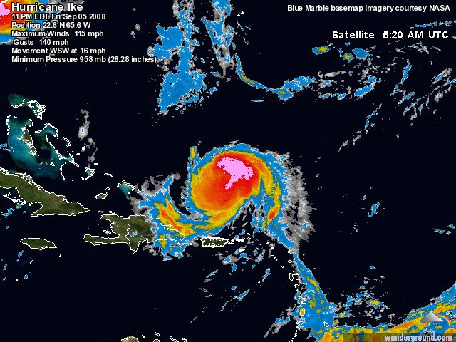
IKE is progressing westerly and will be near where Hanna is now on Monday September 08. This storm has the potential to be a Major Hurricane with a possible track into the Gulf of Mexico by early next week. Several steering currents are going to be affecting the overall movement and it is difficult, nearly a week out, to precisely project it’s path. However, persons in Florida and the Gulf Coast states should be monitoring this storm’s movement as well.
Please use the first link below for Tropical System information and the second link below for active watches, warnings and data.
http://www.nhc.noaa.gov/
http://www.weather.gov/largemap.php
================================================== =======
“THIS IS NOT AN OFFICIAL ADVISORY. These updates and advisories are based upon information from our own computer models, NOAA, Local Weather Data Centers, deep water Buoy Data, and other publicly available sources. FOR THE SAFETY OF YOUR PROPERTY AND PERSON, please refer to your Local, State, and Federal Authority updates for Official Advisories and Orders. For up to the minute advisories and official updates, it is essential that you monitor your local Emergency Government, NOAA and Local Media Broadcasts. Please do not make personal safety decisions based upon information presented here in this Unofficial Advisory.”
================================================== =======
Video – Gustav – Orange Beach
Hurricane Gustav – Orange Beach – Alabama Point
Tropical Storm Ike
Hurricane Hanna
GUSTAV ADVISORY – Monday, September 01
HURRICANE GUSTAV ADVISORY 07:15 Hrs CDT USA, 01 September 2008.
As our information suggested several days ago, Hurricane Gustav will be making landfall this morning near Morgan City, Louisiana at Catagory 3 levels.
‘Landfall’ in the weather community is defined as when the lowest pressure area of the storm crosses the coastline.
Persons in southern Alabama and Mississippi have been under tornado watches and warnings for the past 6 to 8 hours along with very heavy rains and gusty winds. Hurricane spawned tornados are usually much weaker than tornados which form in the Great Plains – usually not higher than EF-1, but can devastate local areas and buildings. The storm surge and wave action in the northeast quadrant (upper right area) of this hurricane is being felt along the southeastern sections of Louisiana and flooding is taking place in numerous areas. Wind gusts have been monitored at 64 MPH in New Orleans and at 86 MPH in Boothville, Louisiana and trees and power lines are going down throughout the region. High surf is being seen all the way to the Florida Panhandle this morning with tropical storm force winds.
Please use the first link below for Tropical System information and the second link below for active watches, warnings and data.
http://www.weather.gov/largemap.php
================================================== =======
“THIS IS NOT AN OFFICIAL ADVISORY. These updates and advisories are based upon information from our own computer models, NOAA, Local Weather Data Centers, deep water Buoy Data, and other publicly available sources. FOR THE SAFETY OF YOUR PROPERTY AND PERSON, please refer to your Local, State, and Federal Authority updates for Official Advisories and Orders. For up to the minute advisories and official updates, it is essential that you monitor your local Emergency Government, NOAA and Local Media Broadcasts. Please do not make personal safety decisions based upon information presented here in this Unofficial Advisory.”
================================================== =======