Have you ever noticed how, even after a recent disaster, people felt immune? It is almost like we are teenagers, and thus, in our own minds, invulnerable. We witnessed the horrors visited on those who stayed for Camille, and spawned a rumor that those that died were having a “hurricane party” and all but said, “They deserved it”.
Then we have years of complacency, and it happens again. This time named Fredrick. Now of course, the toll on human losses was much less than Camille, but the property losses, human suffering, and grief were tremendous. Again there was an outpouring of sympathy for those affected, and an under-current of, “well, they should not have stayed…”
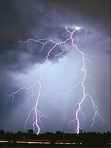
Miami, the city of a million dreams, received a wake up call in the name of Andrew. Massive destruction, loss of life, and abject terror reigned. We all sat in awe as we watched the footage of houses (or their remains) spray painted with insurance policy numbers and ROE numbers (Right of Entry). We were stunned as the inland damage looked more like footage from a twister in Oklahoma, not a hurricane in beautiful southern Florida. Months after Andrew, I was in Miami on business. On the 23rd floor of a high-rise, I watched the sky darken; fat drops of rain began to fall. The wind howled, and the sky exploded into cascading sheets of rain, the air scorched by explosions of lightning and thunder. Three of the local ladies who were working, stared out the window as if they saw the Grim Reaper. One fell to the floor moaning, another, in a tremulous voice said, “A hurricane, I did not hear about a hurricane”, and the other lady almost made it to the restroom as she threw up. It was only a severe storm. But the fear remained.
Weather science has become much more precise and gives us more warning than ever before. Even so, there are large errors that can occur. One such error was named Opal. While the damage in the coastal areas of Alabama and Florida were considerable, the damage well inland was catastrophic. Tornados, flooding, straight line winds, and incredible losses across the board sang their songs well into the days after landfall.
One almost thinks there is a lesson to be learned, and the obvious lesson is really not it. One may think that any who live on barrier islands like our beloved Gulf Shores should give the island back to the sea and wind. One may think that any who lives in shaking Los Angeles should give the city back to rocks and fires. One may think that any who lives under the shadows of Washington’s or any other volcanoes should give the land back to the ashes and lava.
The fact is we love our homes, our location, and our way of life. For many of us, each storm makes our resolve that much firmer. I challenge anyone to find me a person in Gulf Shores, L.A., Hawaii, and so on who is not acutely aware of the potential for catastrophe.
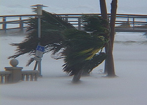
 Enter Ivan. Over a million evacuated the Gulf Coast, and many stayed. Of those that stayed, the terror and devastation of this night storm was unlike many others. That fear has held true even today. Many friends of mine who live in the Pensacola and Milton areas swore “Never again”, they recounted the tales we have all heard; doorbells ringing incessantly into the night as the wind pressed the button, strange shuddering sounds and a feeling of vertigo, resting against a wall and feeling it vibrate like a tuning fork, the noise of the wind entering between window and door seams and sounding like a badly played trombone and occasionally sounding like a chord from the skies, climbing to the attic to escape the water only to find that the water beat them there, and the list goes on.
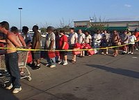
Since Ivan, even the mention of a hurricane or tropical storm sends people in Pensacola, Milton, and Navarre Beach into a panic. They snatch up gas, pack their cars, and almost seem poised to take off like racers at the starting line.
Dennis. People from Gulf Shores to Pensacola watched him like hawks. Bags were packed, reservations made, plywood once again adorned windows like obscene decorations. Being a compact, strong, and fast storm, all predictions, models, and forecasting essentially went out the window. Landfall estimates as late as 8 hours to landfall swung like a pendulum from the Alabama/Mississippi line to Panama City. 4 hours to landfall, and the majority of the professional and amateur forecasters (including this one) started screaming “right up Mobile Bay as a Cat FOUR!!!” Landfall occurred at Navarre Beach as a very weak Category Two with an extremely small wind field. The vast sigh of relief generated almost as much energy as the Labor Day hurricane of 1935.
This hurricane-on-a-half-shell fooled nearly everyone in speed, size, and destination.
Meanwhile, the Gulf of Mexico waters continued to warm. Several noticed, and alarms went off in the minds of those who, while already shocked at the record breaking season of 2005, began to look ahead to the “peak” of the Hurricane Season.
The fear that was in Miami had long since faded, though Pensacola remained in shock from Ivan. The first taste of disaster was but a few scant days away.
A disturbance that only weather enthusiasts and meteorologists paid any attention to was spinning up due east of Miami. Katrina was born amid little notice or concern. She marched towards Miami and Southern Florida with determination, and was met with jeers. This cute little tropical storm with a cute little name would bring some showers. Big deal. Just before landfall, she tried to make her intentions known, intensifying to a Category One storm. Even then, as she quickly became Killer Katrina by dropping trees on occupied vehicles, many weather outlets declared ON AIR that she would weaken to a tropical depression before leaving Florida. Those in the Keys as far south as Key West saw no need of concern.
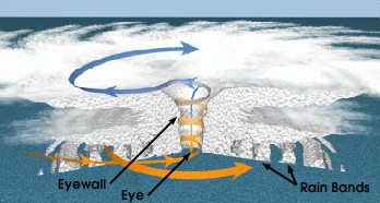
For what seemed like a few scant hours, Killer Katrina did weaken to a tropical storm, but as she tasted the warm, enticing waters of the Gulf of Mexico, she began to strengthen. She strengthened OVER LAND. Key West rapidly discovered that these “rain bands” were in fact her outer edge and became inundated with water. Talk of evacuation surfaced, but it was too late. Many began to realize the size and fury of what they thought of as “Kitten Katrina”.
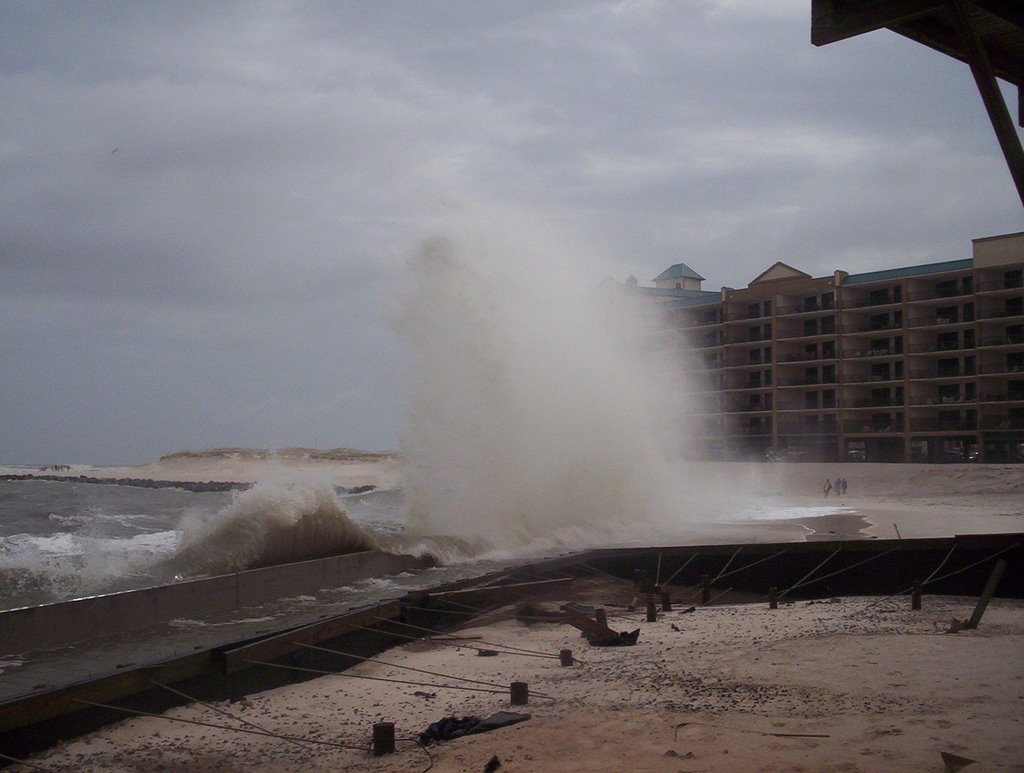
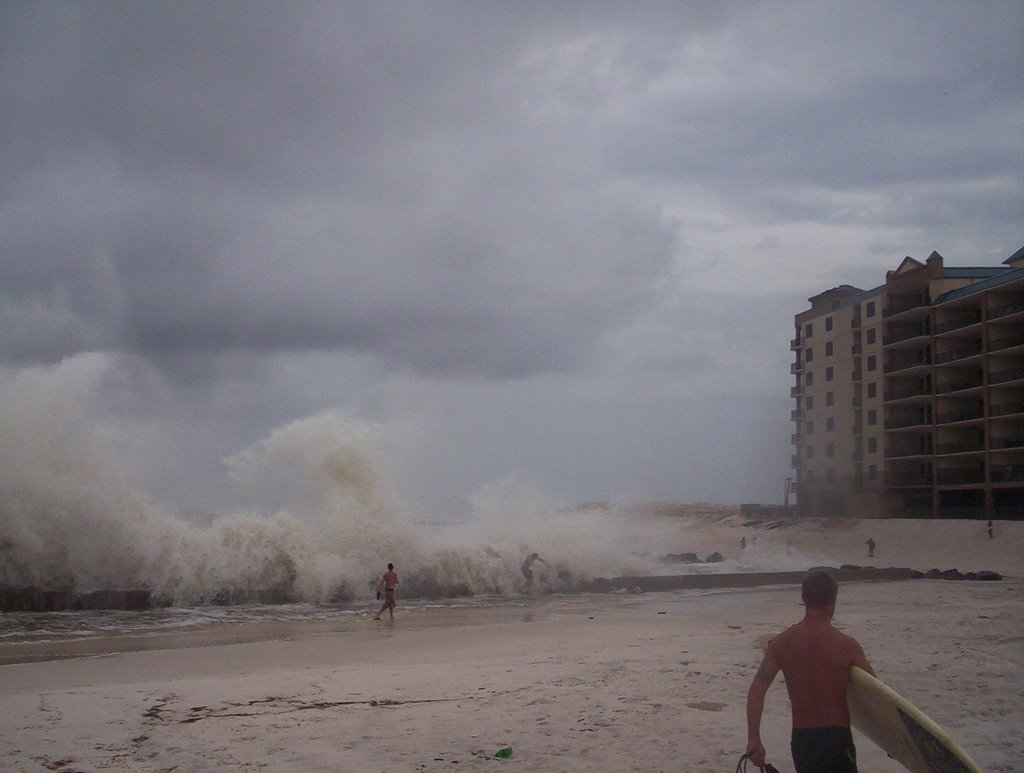
Killer Katrina entered the Gulf of Mexico with a vengeance. If this writer were a superstitious man, I would attest that she took offense to the nonchalance with which she was received at her first landfall and was determined to prove her point. She drank the moist air and bathed in the warm waters, sending large waves crashing from Panama City, Florida to Corpus Christi, Texas. Bay water levels began to rise.
Seasoned veterans of storms, from fishermen to “locals” felt something was bad wrong in the Gulf.
From New Orleans, Louisiana to Mobile, Alabama, many had the basic stance of, “Oh no, those poor people in Baldwin and Escambia Counties, they are going to get hit again.”
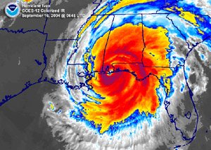
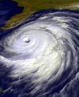
Killer Katrina strengthened into one of the most powerful storms in recorded history. Unbelievable low pressure, massive waves, sustained winds to rival the fiercest of tornados, and so she spun, moving ever slow, and taking aim.
The models and the media shifted their “cone of impact” left and right. Concern grew exponentially along the Gulf Coast, and almost like a sleeping giant, many in Mississippi “woke” to the threat.
Killer Katrina wobbled this way and that, and with her, so did the impact cone. When it was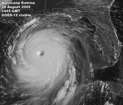 almost too late, she finally became kittenish. She wobbled one last time, much like a kitten getting ready to pounce on a non-assuming ball of paper, and then she leapt.
Instead of a purr and a meow, she roared across Pass Christian, Mississippi, her effects felt hundreds of miles in all directions. The loss of property was staggering, the loss of life, unfathomable. Even after her passing; as red, crying eyes turn once again to the seemingly placid waters of the Gulf, her full impact is yet unknown. But we do know this: From Europe to Asia, the entire world now understands no one is immune to disaster. For now.