Tropical Storms – Bill and Ana

Tropical Storm Ana and Bill continue their westward advancement in the Atlantic.
The SAL and SST’s are favorable for development and the shear battling Ana should lessen.
Ana remains a small storm, but is predicted to develop over the next few days and has a good chance of reaching hurricane status. Bill, on the other hand, is a larger storm, with conditions more favorable for continued development. Bill has the potential to become a major hurricane, reaching Catagory 3 or higher. Bill is tracking roughly a thousand miles behind Ana, and both could emerge into the Gulf of Mexico.
An area of disturbance in the south east Gulf of Mexico bears watching, although the potential for development remains at less than 30% as evidenced in the NOAA/NHC graphic above. Currently, this system is expected to be a rain maker for the north east Gulf Coast. Some severe weather could result from this system as it approaches land.
Elsewhere in the tropics, a strong tropical wave has moved off the coast of Africa, bringing the potential for development. We will have further updates and information as these systems continue to progress.

Tropical Storm Ana –

Tropical Storm Ana formed out of the remnants of Tropical Depression # 2. This area of low pressure is continuing to further develop and is moving westerly at approximately 15 miles per hour. The central winds in this moderately compact storm are currently at 42 MPH with higher gusts to near 60 mph. Persons with interests in the Leeward Islands of the Caribbean Sea should monitor this storm’s progress for Sunday – into Monday, August 16-17. This storm will increase in it’s current intensity as it gets into the warmer waters of the Caribbean. The projected track at this time takes it very near to southern Florida on Wednesday into Thursday, August 19-20. Additional updates on Tropical Storm Ana will be posted as conditions warrant.

We are also carefully watching a rapidly developing Tropical low pressure area which is currently 500 miles west-southwest of the Azores. This storm is farther to the south than Tropical Storm Ana and is in an area where abundant moisture for thunderstorm development is present. There is also very little upper level wind shear at this time which may allow this Tropical low to intensify quickly. This Tropical low has the track potential to be near the southern Gulf of Mexico by the weekend of August 21-23, although there are several variables which may affect this storm system as it approaches the central Caribbean. We are monitoring this situation as well and will update information as necessary.

There is also a Tropical wave approaching the Florida Keys at this hour with significant rainfall and gusty winds. This area will cross into the southeastern Gulf of Mexico later today on a northwesterly track, and persons along the west coast of Florida, southern Alabama and Mississippi can expect occasional thunderstorm activity over the next few days.

For official updates, please refer to:

http://www.nhc.noaa.gov/

==================================================

“THIS IS NOT AN OFFICIAL ADVISORY. These updates and advisories are based upon information from our own computer models, NOAA, Local Weather Data Centers, deep water Buoy Data, and other publicly available sources. FOR THE SAFETY OF YOUR PROPERTY AND PERSON, please refer to your Local, State, and Federal Authority updates for Official Advisories and Orders. For up to the minute advisories and official updates, it is essential that you monitor your local Emergency Government, NOAA and Local Media Broadcasts. Please do not make personal safety decisions based upon information presented here in this Unofficial Advisory.”

==================================================

TD2 In the Atlantic

TD2 has formed in the Atlantic and could become a tropical storm as early as tonight. As the storm develops we will be posting more detailed information. It is too soon to tell what if any threat this system might pose to interests of the United State.

El Nino in force

We are seeing increased activity in the Pacific Basin and little to no activity in the Atlantic. This is typical during an El Nino event. While the Sea Surface Temperatures remain condusive for development in the Atlantic, high shear and the SAL are inhibiting development.

As we edge into Fall, we could see more development of systems in the Atlantic and the Gulf of Mexico, but for now, in our neck of the woods, all remains quiet.

July 07, 2009 – Still Quiet in the Tropics

In recent years, we would already have posted at least one series of comments about a named Tropical Storm. However, this year, things are staying quiet. There are two main reasons for this at the moment. First, there is fairly cool water in the Inter-Tropical Convergence Zone – That area which circles the earth near the Equator where the Northern and Southern ‘Trade Winds’ meet and where storm formation convection (atmospheric lifting) takes place. The other reason is that the upper level winds over the Gulf of Mexico and over the Central Caribbean, are fairly strong and moving rapidly. Whenever surface low pressure thunderstorms form, these upper level winds shear the top off of the storms and they loose the ability to strengthen.

As we get further into July, August and September, these upper level winds will most likely lessen in speed and that is part of the formula that creates Tropical Depressions and Tropical Storms.

We are on top of things and are monitoring the entire Atlantic, Caribbean and Gulf basin for any signs of development and will let our viewers know when these systems occur – especially the one’s that may influence southern Alabama, the Panhandle of Florida and southeastern Mississippi.

For those who wish to do some interesting studies, please use this NOAA link below. Thank you, from the Tropical Storm Research Center in Gulf Shores, Alabama.

http://earthobservatory.nasa.gov/IOTD/view.php?id=703

Information Concerning Eastern Pacific Storm Tracking

Many of you have seen that “Tropical Depression 1-E” has formed in the Eastern Pacific off the coast of western Mexico. This storm will move northeasterly and inland over the weekend and will bring rains to the southwestern US and especially Texas.

We are only mentioning this today because some persons might see “Tropical Depression 1-E” on TV and wonder why we are not tracking the storm. The Tropical Storm Research Center in Gulf Shores, Alabama, does not routinely track Eastern Pacific storms UNLESS they cross over Mexico or Latin America and enter the Caribbean Sea or the Gulf of Mexico. Our tracking of Atlantic, Caribbean and Gulf storms is our primary responsibility because they can ultimately affect the Gulf Coast of the United States where the majority of our viewers reside. Thank you.

http://www.weather.gov/largemap.php

==================================================
“THIS IS NOT AN OFFICIAL ADVISORY. These updates and advisories are based upon information from our own computer models, NOAA, Local Weather Data Centers, deep water Buoy Data, and other publicly available sources. FOR THE SAFETY OF YOUR PROPERTY AND PERSON, please refer to your Local, State, and Federal Authority updates for Official Advisories and Orders. For up to the minute advisories and official updates, it is essential that you monitor your local Emergency Government, NOAA and Local Media Broadcasts. Please do not make personal safety decisions based upon information presented here in this Unofficial Advisory.”
==================================================

Invest 90L

Invest 90L is being monitored by the National Hurricane Center. The area of disturbance is located in the Eastern Carribean and does have a possibility to further develop.

Barely 12 hours after the initial post, Invest 90L has been absorbed by the Low Pressure System over Florida and is no longer considered a threat to develop.

Changes to NHC Services

PRODUCT CHANGES FOR THE 2009 HURRICANE SEASON

Effective May 15, the National Hurricane Center will implement important changes in some of its text and graphical products. It will also make some additions to its Web site and experimental products. This is part of a continuing effort at the National Hurricane Center to expand and enhance its level of service.

Changes:

1) The Tropical Cyclone Storm Surge Probability products, previously experimental, will become operational. In addition, the products will be available with thresholds of one foot increments ranging from two to 25.

2) The Atlantic and Eastern Pacific Tropical Cyclone Wind Field Graphics will become operational.

3) The Atlantic and Eastern Pacific Graphical Tropical Weather Outlooks will become operational.

4) The Monthly Tropical Weather Summary will have a change in content. It will be in tabular form, displaying the latest seasonal statistics (names of storms, dates, estimated peak intensities and minimum central pressure) with a short narrative of records of interest, if any. Individual storm narratives will no longer be included.

5) Changes to the Public Advisory will include an easier-to-read “Repeat” section near the end of the advisory, and the “Zulu” or “Z” time designation will be replaced by “UTC”.

6) The Tropical Cyclone Discussion and Public Advisory will be issued with the same time zone designation.

7) The “Special Tropical Disturbance Statement” will be discontinued and replaced with a “Special Tropical Weather Outlook”. The Special Tropical Weather Outlook will be issued when significant changes have occurred to disturbances between the regular Outlook issuance times.

8) Storm surge information and forecasts in the Public Advisory will be expressed in terms of “height above ground level” or “inundation”.

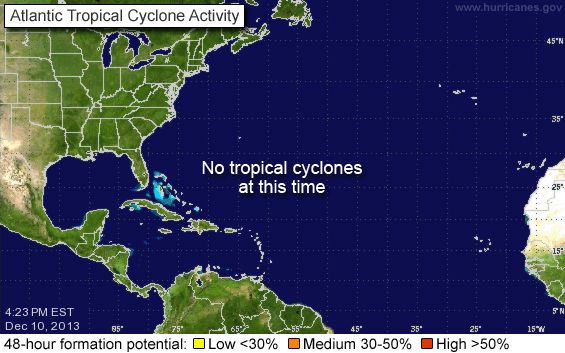
9) The thresholds for the low/medium/high risk of tropical cyclone development will be adjusted. The new thresholds will be: Low risk: Less than 30 percent; Medium risk: 30 to 50 percent; High risk: Greater than 50 percent.

10) The risk of tropical cyclone development outlook (low, medium or high) will be added to the text version of the Tropical Weather Outlook. The text outlook will include the same categorical chance of development shown in the Graphical Tropical Weather Outlook.

11) The size of the tropical cyclone forecast cone will be adjusted. The cone represents the probable track of the center of a tropical cyclone, and is formed by enclosing the area swept out by a set of imaginary circles placed along the forecast track (at 12, 24, 36 hours, etc.. The size of each circle is set so that two-thirds of historical official forecast errors over a 5-year sample fall within the circle.

Website Additions:
12) Graphical Tropical Weather Outlook RSS/XML feed
http://hurricanes.gov/gtwo.xml

13) Improved version of website for PDAs and Smartphoneshttp://hurricanes.gov/mobile

These are very exciting additions to a most excellent service provided by NOAA.

Beginning on May First

Our regular updates will resume beginning on May 1st, 2009. This year we have added the disctinction of SKYWARN Spotter, Fox 10 TV STORMtracker, and ABC 33/40 SkyWatcher.

We look forward to providing rapid and timely information and insight as the 2009 Hurricane Season approaches.

March 17, 2009 – Dense Fog Advisory

Because of light winds and rain saturated ground moisture in places, the National Weather Service has issued a Dense Fog Advisory for southern Mississippi, southern Alabama and the Panhandle of Florida for this morning March 17. Visibilities averaging less than 1/4 mile regionally can be expected until mid morning. Use caution while driving as visibilities of less than 400 feet can be anticipated in some areas.

http://www.srh.noaa.gov/mob/

http://www.weather.gov/largemap.php

================================================== =======

“THIS IS NOT AN OFFICIAL ADVISORY. These updates and advisories are based upon information from our own computer models, NOAA, Local Weather Data Centers, deep water Buoy Data, and other publicly available sources. FOR THE SAFETY OF YOUR PROPERTY AND PERSON, please refer to your Local, State, and Federal Authority updates for Official Advisories and Orders. For up to the minute advisories and official updates, it is essential that you monitor your local Emergency Government, NOAA and Local Media Broadcasts. Please do not make personal safety decisions based upon information presented here in this Unofficial Advisory.”
=========================================================