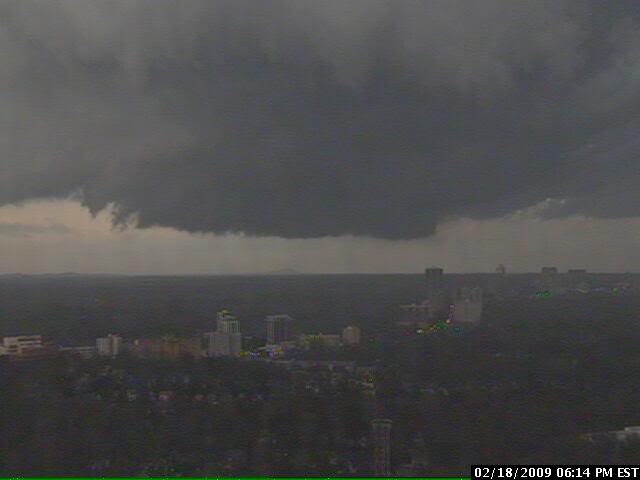
The picture above is a wall cloud over Atlanta. Numerous reports of large hail, tornadoes, and strong winds have been recieved. Our area is in a “slight” risk zone, however we can expect strong to severe thunderstorms over the evening hours.
Unofficial Advisory: US South and Central States-Feb 11-12
Unofficial Advisory for the south & central states for Wednesday, Feb. 11 and Thursday Feb. 12.
Our tracking software is indicating another severe weather possibility for parts of Oklahoma, Kansas, Nebraska, Louisiana, Mississippi, Missouri, Alabama, Tennessee, Kentucky, Illinois, Indiana and Ohio for the next 24 to 48 hours. Severe thunderstorms, high winds and tornadic activity is possible in these areas. Please monitor local media and NOAA weather radio stations for official watches, warnings and alerts. You can also use the NWS alert link below. Take care and be safe.
http://www.weather.gov/largemap.php
================================================== =======
“THIS IS NOT AN OFFICIAL ADVISORY. These updates and advisories are based upon information from our own computer models, NOAA, Local Weather Data Centers, deep water Buoy Data, and other publicly available sources. FOR THE SAFETY OF YOUR PROPERTY AND PERSON, please refer to your Local, State, and Federal Authority updates for Official Advisories and Orders. For up to the minute advisories and official updates, it is essential that you monitor your local Emergency Government, NOAA and Local Media Broadcasts. Please do not make personal safety decisions based upon information presented here in this Unofficial Advisory.”
================================================== =======
Preliminary 2009 Hurricane Season Info
Several so called ‘experts’ from the State University system in Colorado are mentioning that the 2009 Tropical Storm and Hurricane Season could be a near-identical copy of 2008 or even more intense, to a degree. I’d like to see their computer projection program because that type of prediction this far out is meaninless.
Our own studies group will be running our own analysis data in early May to see the general scheme of things. We will also be posting Hurricane Preparation and personal safety information in this area as the season draws near.
This is the list of names for significant Tropical Weather Systems for 2009:
Ana
Bill
Claudette
Danny
Erika
Fred
Grace
Henri
Ida
Joaquin
Kate
Larry
Mindy
Nicholas
Odette
Peter
Rose
Sam
Teresa
Victor
Wanda
For us, fairly quiet.
Hard Freeze Warning for Southern Baldwin County
Just an early morning reminder to take care of your water pipes by allowing outdoor faucets on elevated residences to drip slightly to prevent broken copper and PVC pipes. The cold temperatures this morning will give way to a slight warmup over the next few days. Take care and stay warm!!
Severe Weather Threat
Special Weather Statement – South, Central and North Central USA
Special Weather Statement Monday Dec. 08, 2008 – 12:30 PM USA CST
A very strong winter storm is intensifying in the Central Plains states today. This intense low pressure area will bring the potential for severe thunderstorms to the South Central and Gulf Coast states Monday night into Tuesday as well as icing conditions in the Central states and near blizzard conditions in the North Central states. Hazardous conditions will be present over the next 24 to 48 hours in these areas and travel will be difficult – especially in the ice and snow forecast areas. Please use the link below for local advisories, watches and warnings.
http://www.weather.gov/largemap.php
================================================== =======
“THIS IS NOT AN OFFICIAL ADVISORY. These updates and advisories are based upon information from our own computer models, NOAA, Local Weather Data Centers, deep water Buoy Data, and other publicly available sources. FOR THE SAFETY OF YOUR PROPERTY AND PERSON, please refer to your Local, State, and Federal Authority updates for Official Advisories and Orders. For up to the minute advisories and official updates, it is essential that you monitor your local Emergency Government, NOAA and Local Media Broadcasts. Please do not make personal safety decisions based upon information presented here in this Unofficial Advisory.”
==================================================
Hurricane Paloma
Tropical Storm: ‘Paloma’
Tropical Storm Paloma developed over the past 36 hours from a tropical depression in the western Caribbean. The storm is forecast to make Hurricane status sometime on Friday. The storm will cross central Cuba to the northeast on Sunday and Monday and will also affect the Bahamas and south Florida.
Persons in the Florida Keys and the southern counties in Florida or who plan on visiting those areas are being asked to watch the progress of this storm carefully. We will post additional information as it becomes available.
Please use the first link below for Tropical System information and the second link below for active watches, warnings and data.
http://www.nhc.noaa.gov/
http://www.weather.gov/largemap.php
================================================== =======
“THIS IS NOT AN OFFICIAL ADVISORY. These updates and advisories are based upon information from our own computer models, NOAA, Local Weather Data Centers, deep water Buoy Data, and other publicly available sources. FOR THE SAFETY OF YOUR PROPERTY AND PERSON, please refer to your Local, State, and Federal Authority updates for Official Advisories and Orders. For up to the minute advisories and official updates, it is essential that you monitor your local Emergency Government, NOAA and Local Media Broadcasts. Please do not make personal safety decisions based upon information presented here in this Unofficial Advisory.”
==================================================