
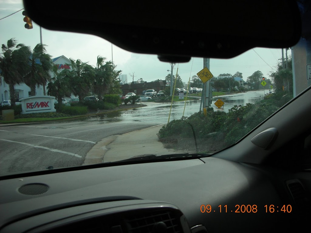
Ike in Gulf Shores
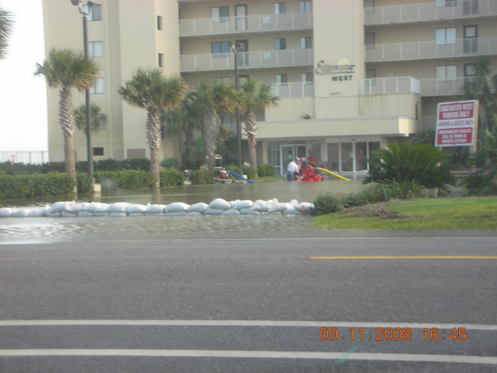
Edgewater West on west beach. They were trying to pum the water out, but it is rising faster than thy can remove it.
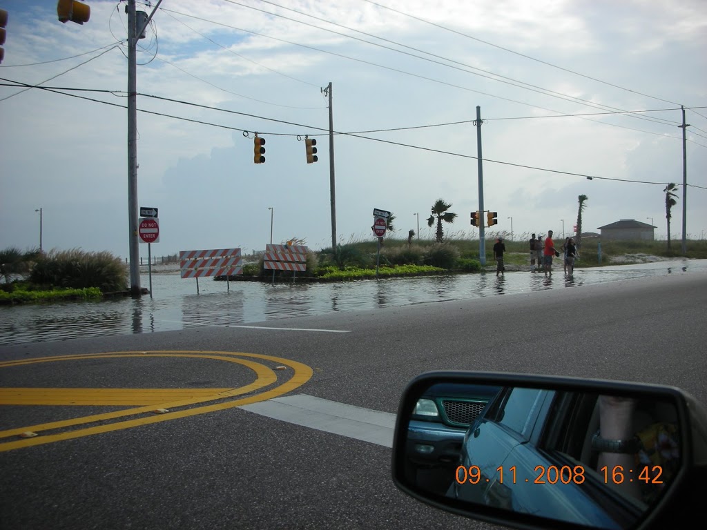
The next picture is of west beach just past the “T” in Gulf Shores Alabama. Many roads and areas towards Ft. Morgan are flooded with water over the road in numerous places in Gulf Shores.
Ike remains on track to Texas, and due to his shear size, we are feeling the effects of Ike even here. For the most part, conditions remain good here, but we can expect things to deteriorate somewhat as Ike continues his trek through the Gulf of Mexico.
The behemoth named Ike
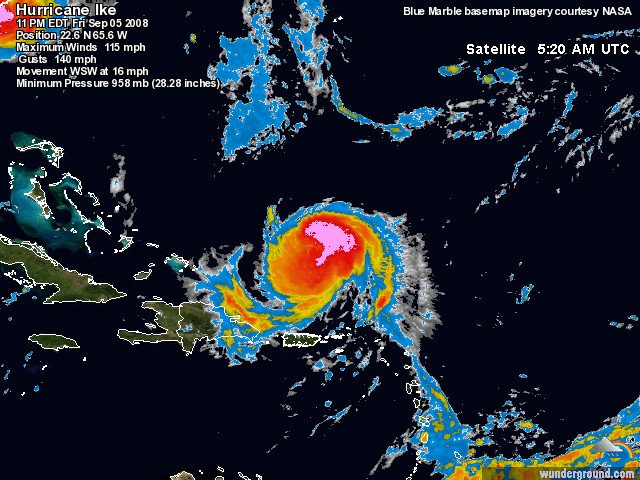
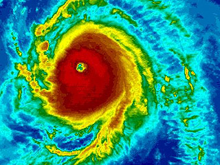
![]() Possible Catagory Four Landfall
Possible Catagory Four Landfall
Ike looks to be a catagory FOUR at landfall on the Texas coast. Ike is a huge storm and is strenghtening rapidly. The upper level trough is wreaking havoc with the forecasts, and could push Ike into Louisiana.
For our area, odds are against us getting a direct hit, but sadly, that is not outside of the realm of possibility. Gulf Shores and Orange Beach should expect periods of tropical storm and/or hurricane conditions as Ike makes his final move inland at or near Texas.
Surge is expected to be in excess of 18 feet with winds as high as 150mph at landfall. Our area can expect seas to be 3-8 feet above normal, coastal flooding, and winds 25 to 50mph. Isolated tornados and severe thunderstorms could begin as early as tomorrow night.
IF YOU ARE IN THE PROJECTED PATH OF IKE LEAVE NOW. Hurricane Ike is a VERY DANGEROUS storm, and the loss of life and property is almost a certainty. Tropical Storm force winds are well over 200 miles from the center of Ike. ALL PERSONS ALONG THE GULF COAST should monitor Ike closely.
Easy, Automated, Fast, Secure, Reliable & Offsite
Protect your most valuable asset — your DATA — with our state-of-the-art Web-based backups. Enjoy the convenience of Easy System Restore, Remote File Access, 10-File Versioning, Secure Account Sharing and more.
Start your FREE 30-day online backup trial, and learn more »
Hurricane Ike
Hurricane Ike has weakened to a Catagory ONE storm as the mountains of Cuba continue to shred him.
At the time of this writing, all models are in agreement that Ike’s final landfall will be along the Texas coast. The latest recon reported:
AT 200 AM EDT…0600Z…THE CENTER OF HURRICANE IKE WAS LOCATED BYCUBAN AND KEY WEST RADARS NEAR LATITUDE 21.9 NORTH…LONGITUDE 81.5WEST JUST SOUTH OF THE ZAPATA PENINSULA AND ABOUT 95 MILES…150KM…SOUTHEAST OF HAVANA CUBA.THE METEOROLOGICAL CENTER IN CASABLANCA HAVANA JUSTREPORTED A WIND GUST TO NEAR 62 MPH…100 KM/HR. SAND KEYAUTOMATIC STATION JUST SOUTHWEST OF KEY WEST RECENTLY REPORTEDSUSTAINED WINDS OF 50 MPH…80 KM/HR AND A GUST OF 67 MPH…107KM/HR.
The interaction with Cuba before emerging into the Gulf of Mexico. ALL models point westward for Ike, and for our area that is a good thing. Things can and do change. Please stay ready to take any action required to protect your life and property.
Preliminary Preparedness Information
We will be presenting a more in-depth instruction on hurricane preparedness very soon, but at this time, due to the possibility of Hurricane IKE being a Gulf Storm by Tuesday, September 09, we would just like to list several things to do that are at the top of the preparedness list.
Most important is awareness. This includes monitoring your local media and the National Weather Service and their Alert Radio Stations for information about Tropical Systems that can potentially affect your area of residence. Being prepared to evacuate when the orders are given by local Emergency Government Officials is critical to your safe travel out of the area.
Things to do: Motor vehicles should be in proper mechanical shape with a full fuel tank and good quality tires when there is even a hint of trouble heading your way. Place the following items in heavy duty weathertight storage bags with waterproof labels on each – Enough cash to last 10 days away from your residence. Cell phones, chargers and extra batteries. Prescription medication that your family members need and a well stocked first aid kit. Your important documents and papers that can not be replaced. All keys for your vehicles, home, office, safe deposit box and your properties. Family photos that can not be replaced. Bottled drinking water in your vehicle – 1 gallon per person per day while on the road out of the evacuation area. Three ‘energy bars’ per day for each person in your vehicle. Toilet tissue. Three changes of clothing for each person as well as extra shoes. Raincoats for each person with you. A flashlight for each person with you. Portable battery powered broadcast radio and a portable National Weather Service Radio with extra batteries for both.
Most shelters now accept pets or can make arrangement for pet care. According to FEMA guidlines, take your pets with you and enough food and water for their trip plus 5 to 7 days confinement. Before you leave your residence, board up the windows and doors as suggected by your local Emergency Government. Empty your refrigerator and freezer of perishable food items. Turn off your natural or LP gas. Turn off your electrical panel main breaker. Turn off your water at the meter or ground connection to your home.
When you hear the evacuation orders, leave immediately and follow the marked Evacuation Routes as mentioned in the orders. Do NOT make your own shortcuts because if you have an accident, law enforcement and rescue may not be able to get to you OFF of the established routes.
We wish for everyone to remain safe in the face of these terrible storms. The lessons learned during Hurricane Katrina should be a wakeup call for everyone who lives in a hurricane prone area. Prepare ahead of time, have a family plan and when the evacuation orders are given – LEAVE !
More information to follow soon. Thank you.
The Future of Ike
All interests from Florida to the northern gulf coast should pay very close attention to Ike.
Ike remains our second credible threat of the season. If many of the models verify, Cuba will “work him over” but Gustav did not stir the GoM enough to prevent him from re-strengthening. Shear could become a factor.
Infared satellite imagery shows Ike as a well defined system, but he is looking a bit rougher on the latest images. On one forum, I had been asked my my personal thoughts were for a north/central Gulf of Mexico landfall might be, and at that very early stage, I suggested around 30%. If pressed at the time of this writing, I would double that number.
Hurricane IKE Update 6 AM Friday
HURRICANE IKE Update – 05 September 2008.
Hurricane IKE is located approximately 450 miles north of the Leeward Islands with westerly forward movement that will place it near the Bahamas by Sunday, September 07. The storm is undergoing strength changes but is still a very dangerous Catagory 3 hurricane with additional strengthening probable. Persons in South Florida as well as the Gulf Coast States and the Southeastern States should be monitoring this storm. It has a very wide track possibility at this time and many coastal communities could be at risk. We will post more precise tracking information later this weekend when the steering currents are more well defined. Persons in the Miami area should be particularly alert to this storm.
Please use the first link below for Tropical System information and the second link below for active watches, warnings and data.
http://www.nhc.noaa.gov/
http://www.weather.gov/largemap.php
================================================== =======
“THIS IS NOT AN OFFICIAL ADVISORY. These updates and advisories are based upon information from our own computer models, NOAA, Local Weather Data Centers, deep water Buoy Data, and other publicly available sources. FOR THE SAFETY OF YOUR PROPERTY AND PERSON, please refer to your Local, State, and Federal Authority updates for Official Advisories and Orders. For up to the minute advisories and official updates, it is essential that you monitor your local Emergency Government, NOAA and Local Media Broadcasts. Please do not make personal safety decisions based upon information presented here in this Unofficial Advisory.”
================================================== =======
Ike a Category Four
Ike is a Cat 4 Hurricane and is expected to maintain strength and possibly strengthen. After traversing moderate waters around 75 degrees, he is poised to move into much more favorable conditions over the next 48 hours.
While the path and strength of Ike remains an unknown in terms of landfall, Ike poses a very credible threat to all in its path.
Ike is demonstrating excellent outflow, and has a well defined eye. Southern Florida should monitor this storm, as well as interests in the Gulf of Mexico.
Hanna has weakened somewhat and appears to be headed for the Carolina’s as Josephine seems determined to go play with the occassional flying fish.
Hurricane Ike
![]() Hurricane Ike continues his westwardly movement. The models in the figure to the left hint at a possible emergence into the Gulf of Mexico, however, they also suggest a sharp recurve to the north near the Florida coastline due to a high pressure system “setting up shop”.
Hurricane Ike continues his westwardly movement. The models in the figure to the left hint at a possible emergence into the Gulf of Mexico, however, they also suggest a sharp recurve to the north near the Florida coastline due to a high pressure system “setting up shop”.
Hanna remans a tropical storm, through some strenghtening is expected. She appears to making a “bee-line” for the east coast, and should turn north and possible skate the eastern seaboard.
Josephine also is continuing west, and looks to be a candidate to become a “fish”, (a slang term for a storm that appears destined to head out into open waters). Sh could pose a threat to Bermuda, though her future track is even less certain than those questions surrounding Hanna and Ike.
Combined Update for Storms Hanna and Ike
TROPICAL STORM HANNA AND TROPICAL STORM IKE update 05:30 Hrs CDT USA, 03 September 2008
Recapping BOTH storms closest to the US mainland in combined subtopics:
HANNA is turning to the north northwest from it’s location in the Bahamas. This will affect the Atlantic coast of Florida, as well as coastal Georgia and the Carolinas starting late Thursday into the weekend. Hanna is forecast to become a Cat 1 Hurricane again sometime within the next 24 hours and possibly strengthen even more. Persons in the areas mentioned above should be monitoring this storm’s progression. Significant rainfall, high surf, rip currents, tornadoes, beach errosion and frequent cloud to ground lightning will be present along the east coast of the United States as this storm moves northerly along the coast over the next 5 to 8 days.
IKE is progressing westerly and will be near where Hanna is now on Monday September 08. This storm has the potential to be a Major Hurricane with a possible track into the Gulf of Mexico by early next week. Several steering currents are going to be affecting the overall movement and it is difficult, nearly a week out, to precisely project it’s path. However, persons in Florida and the Gulf Coast states should be monitoring this storm’s movement as well.
Please use the first link below for Tropical System information and the second link below for active watches, warnings and data.
http://www.nhc.noaa.gov/
http://www.weather.gov/largemap.php
================================================== =======
“THIS IS NOT AN OFFICIAL ADVISORY. These updates and advisories are based upon information from our own computer models, NOAA, Local Weather Data Centers, deep water Buoy Data, and other publicly available sources. FOR THE SAFETY OF YOUR PROPERTY AND PERSON, please refer to your Local, State, and Federal Authority updates for Official Advisories and Orders. For up to the minute advisories and official updates, it is essential that you monitor your local Emergency Government, NOAA and Local Media Broadcasts. Please do not make personal safety decisions based upon information presented here in this Unofficial Advisory.”
================================================== =======