Tropical Storm Isaac: Discussion

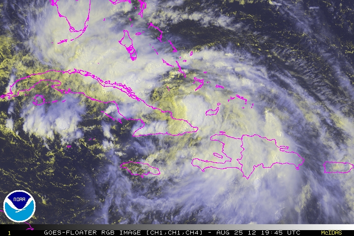
Tropical Storm Isaac is skirting the northern coast of Cuba, mostly avoiding the 6,000 foot mountains that have caused havoc on storms in years past.  Once Isaac moves into the Gulf of Mexico, the NHC anticipates Isaac to reach Category 2 strength as it approaches the United States.  However, there remains a chance that Isaac could enter a RIC (Rapid Intensification Cycle) and become a Major Hurricane as a Category Three.

Current models trend Isaac to anywhere from as far west as New Orleans to the Destin/Panama City area.  As mentioned previously in this blog, anyone near these areas should be on alert.

CNN reports:

Gov. Rick Scott said he’d declared a state of emergency for Florida, which he said is “standard protocol” to ensure a well-coordinated response with local, state and federal agencies.


What will Isaac Bring?
Regardless of landfall, going with an initial assessment of a Category 2 hurricane, Isaac promises damaging winds, flooding, torrential rains, and storm surge.  Of special importance, the rain bands and thunderstorm clusters also bring EF0 to EF3 tornadoes, which can damage and even destroy well built structures.

One person local to Gulf Shores was trying to re-assure a new resident by saying, “Oh, a Cat One is like a thunderstorm.  A really long thunderstorm.”  There is some truth in that, as even a “weak” hurricane’s effects are more cumulative than dramatic.  The end result, is loss.

What can I expect?
Flash flooding.  Be aware of rising water.  Additionally, the aforementioned tornado threat is very real and you should be prepared to take cover without warning.

In the areas directly impacted, expect to be without power.  Possibly without phone or cell service depending on the severity of the storms in your area.

Further inland, tornados, and flooding will pose a threat, even hundreds of miles inland.  Put simply, it has been seven years since our area has stared down the barrel of a hurricane, and often as not, complacency can and does set in.

What should I do?
Follow the advice and instructions from your local authorities, stay diligent, and be prepared.  Remember, the first 72 hours after a storm are “on you”.

Tropical Storm Isaac Update 25 August 2012, 11:00 AM CDT

Tropical Storm Isaac is centered over eastern Cuba at this time. It is moving to the northwest at 13 to 16 MPH and will be just south of the Florida Keys by Mid Day Sunday, August 26. Once this storm enters the warm waters of the southeastern Gulf of Mexico, it is forecast by the National Hurricane Center to ‘probably’ make Hurricane Category 1 status – sometime Sunday, near the Florida Keys. As it continues in a northerly direction into Monday, the storm may get to Hurricane Category 2 according to the latest advisory from the National Hurricane Center. Because of the possibility of landfall over a fairly wide area, all persons in FLORIDA, SOUTHERN ALABAMA, SOUTHERN MISSISSIPPI and SOUTHEASTERN LOUISIANA should be monitoring the NHC advisories as well as their own local Emergency Operations Center advisories. Most storm models are looking at a Florida Pan Handle landfall late Tuesday into early Wednesday, but because this storm is so wide, most northern and eastern Gulf Coast areas will be affected in some way.

Our next unofficial update will take place as soon as the NHC upgrades Isaac to Hurricane status.

For up to the minute official advisories and information, please visit the NHC website in Miami:

http://www.nhc.noaa.gov/

We are also providing an interactive Watch and Warning web link for persons who wish to get details on localized conditions:

http://www.nws.noaa.gov/largemap.php

=============================================

“THIS IS NOT AN OFFICIAL ADVISORY. These updates and advisories are based upon information from our own computer models, NOAA, Local Weather Data Centers, deep water Buoy Data, and other publicly available sources. FOR THE SAFETY OF YOUR PROPERTY AND PERSON, please refer to your Local, State, and Federal Authority updates for Official Advisories and Orders. For up to the minute advisories and official updates, it is essential that you monitor your local Emergency Government, NOAA and Local Media Broadcasts. Please do not make personal safety decisions based upon information presented here in this Unofficial Advisory.”

http://www.wootaah.blogspot.com

============================================

Tropical Storm Isaac Update, August 24 – 5 AM

Tropical Storm Isaac Update 24 August 2012, 5AM CDT.

Tropical Storm Isaac continues to track generally west-northwestward in the Caribbean south of Puerto Rico and the Dominican Republic. The storm’s intensity has not changed much in 3 days due to an area of dry high pressure air to it’s north. The storm is forecast to cross land at the eastern end of Hispaniola and track across most of Cuba. As it emerges from Cuba early Monday still as a tropical storm, it will start to follow the Florida Gulf Coastline, starting with the Florida Keys. Once the storm gets into the warm waters of the Gulf of Mexico, it may intensify. There is a wide disagreement between the agencies doing the computer modeling for Isaac as to which direction it will go past Monday, August 27.

It is for that reason that we are asking that ALL RESIDENTS of Florida and the coastal areas of Alabama, Mississippi, Louisiana and Texas carefully monitor the progress of this storm and make preparations now.

For up to the minute official advisories and information, please visit the NHC website in Miami:

http://www.nhc.noaa.gov/

We are also providing an interactive Watch and Warning web link for persons who wish to get details on localized conditions:

http://www.nws.noaa.gov/largemap.php

=============================================

“THIS IS NOT AN OFFICIAL ADVISORY. These updates and advisories are based upon information from our own computer models, NOAA, Local Weather Data Centers, deep water Buoy Data, and other publicly available sources. FOR THE SAFETY OF YOUR PROPERTY AND PERSON, please refer to your Local, State, and Federal Authority updates for Official Advisories and Orders. For up to the minute advisories and official updates, it is essential that you monitor your local Emergency Government, NOAA and Local Media Broadcasts. Please do not make personal safety decisions based upon information presented here in this Unofficial Advisory.”

http://www.wootaah.blogspot.com

============================================

ALERT: Named Storm Isaac – August 21, 2012 – 5 PM CDT

Tropical Storm Isaac formed out of Tropical Depression 9 today. We are repeating a previous posting under the new header of Named Storm Isaac.

DATA: The developing storm is approximately 500 miles east of Guadeloupe moving westward at 18 to 21 MPH. Most computer modeling is showing this storm as a Category 2 or 3 hurricane as it travels near Cuba on Saturday, August 25 and Sunday, August 26. If the storm stays over open water a little to the south of most of the Caribbean Islands, this storm will intensify significantly. Even if it takes a slightly northerly track and interacts with the mountains on the islands, this could still be a very dangerous storm as it emerges to the northwest of Haiti.

Due to the forward speed of this tropical system and the potential tracking being shown at this time, we are asking that ALL COASTAL RESIDENTS of the southeastern US and the Gulf Coast States, especially Florida, monitor the progress of this storm diligently.

For up to the minute official advisories and information, please visit the NHC website in Miami:

http://www.nhc.noaa.gov/

We are also providing an interactive Watch and Warning web link for persons who wish to get details on localized conditions:

http://www.nws.noaa.gov/largemap.php

=============================================

“THIS IS NOT AN OFFICIAL ADVISORY. These updates and advisories are based upon information from our own computer models, NOAA, Local Weather Data Centers, deep water Buoy Data, and other publicly available sources. FOR THE SAFETY OF YOUR PROPERTY AND PERSON, please refer to your Local, State, and Federal Authority updates for Official Advisories and Orders. For up to the minute advisories and official updates, it is essential that you monitor your local Emergency Government, NOAA and Local Media Broadcasts. Please do not make personal safety decisions based upon information presented here in this Unofficial Advisory.”

http://www.wootaah.blogspot.com

============================================

ALERT: Tropical Depression 9 – Unofficial Advisory

Tropical Depression Nine is rapidly developing and will become a named storm within 24 hours. The developing storm is approximately 500 miles east of Guadeloupe moving westward at 21 MPH. Most computer modeling is showing this storm as a Category 2 or 3 hurricane as it travels near Cuba on Saturday, August 25 and Sunday, August 26. If the storm stays over open water a little to the south of most of the Caribbean Islands, this storm will intensify significantly. Even if it takes a slightly northerly track and interacts with the mountains on the islands, this could still be a very dangerous storm as it emerges to the northwest of Haiti.

We do not normally make unofficial advisories until a storm is named, however, due to the forward speed of this tropical system and the potential tracking being shown at this time, we are asking that ALL COASTAL RESIDENTS of the southeastern US and the Gulf Coast States, especially Florida, monitor the progress of this storm dilligently.

For up to the minute official advisories and information, please visit the NHC website in Miami:

http://www.nhc.noaa.gov/

We are also providing an interactive Watch and Warning web link for persons who wish to get details on localized conditions:

http://www.nws.noaa.gov/largemap.php

=============================================

“THIS IS NOT AN OFFICIAL ADVISORY. These updates and advisories are based upon information from our own computer models, NOAA, Local Weather Data Centers, deep water Buoy Data, and other publicly available sources. FOR THE SAFETY OF YOUR PROPERTY AND PERSON, please refer to your Local, State, and Federal Authority updates for Official Advisories and Orders. For up to the minute advisories and official updates, it is essential that you monitor your local Emergency Government, NOAA and Local Media Broadcasts. Please do not make personal safety decisions based upon information presented here in this Unofficial Advisory.”

http://www.wootaah.blogspot.com

============================================

Invest 94L

This disturbance off the coast of Africa, has all the markings of a long tracking storm.  While it is entirely to soon to predict the end of this system, it is my personal opinion that ALL U.S. interests should closely monitor this weather system.

Early models do not predict a good outcome, however, many variables remain that could impede 94L’s ultimate progress.  We will be monitoring this system and present data as soon as it is available.

Named Storm Helene

Tropical Storm Helene formed in the southwestern Gulf of Mexico from the remnants of Tropical Depression 7. This storm will be affecting eastern Mexico and will not be directly impacting any US coastal areas, so this will be our only Named Storm Helene unofficial report.

For up to the minute official advisories and information, please visit the NHC website in Miami:

http://www.nhc.noaa.gov/

We are also providing an interactive Watch and Warning web link for persons who wish to get details on localized conditions:

http://www.nws.noaa.gov/largemap.php

=============================================

“THIS IS NOT AN OFFICIAL ADVISORY. These updates and advisories are based upon information from our own computer models, NOAA, Local Weather Data Centers, deep water Buoy Data, and other publicly available sources. FOR THE SAFETY OF YOUR PROPERTY AND PERSON, please refer to your Local, State, and Federal Authority updates for Official Advisories and Orders. For up to the minute advisories and official updates, it is essential that you monitor your local Emergency Government, NOAA and Local Media Broadcasts. Please do not make personal safety decisions based upon information presented here in this Unofficial Advisory.”

http://www.wootaah.blogspot.com

============================================

Named Storm Gordon

In keeping with our committment to report on any tropical storms named by the National Hurricane Center in Miami, we are unofficially reporting this:

Tropical Storm Gordon formed in the central Atlantic over night. Almost immediately, the storm was picked up by the Jet Stream and has been turned to a northeasterly direction. This storm will not be impacting any US coastal areas so this will be our only Named Storm Gordon unofficial report.

For up to the minute official advisories and information, please visit the NHC website in Miami:

http://www.nhc.noaa.gov/

We are also providing an interactive Watch and Warning web link for persons who wish to get details on localized conditions:

http://www.nws.noaa.gov/largemap.php

=============================================

“THIS IS NOT AN OFFICIAL ADVISORY. These updates and advisories are based upon information from our own computer models, NOAA, Local Weather Data Centers, deep water Buoy Data, and other publicly available sources. FOR THE SAFETY OF YOUR PROPERTY AND PERSON, please refer to your Local, State, and Federal Authority updates for Official Advisories and Orders. For up to the minute advisories and official updates, it is essential that you monitor your local Emergency Government, NOAA and Local Media Broadcasts. Please do not make personal safety decisions based upon information presented here in this Unofficial Advisory.”

http://www.wootaah.blogspot.com

============================================

Named Storm Ernesto – Final US Update

Named Storm Ernesto – Update 05:30 AM CDT 07 August 2012.

Ernesto is being steered by the westerly flow of an upper level high pressure area. The storm may make Hurricane status by the time it makes it’s first landfall near Belize on Wednesday. The storm will cross the Yucatan Peninsula and continue westbound over the southern Gulf of Mexico and make a second landfall south of Tampico, Mexico, on Friday. Since this storm no longer poses a threat to the US Gulf Coast, this will be our final Ernesto update. However, persons in Mexico should monitor this storm’s progress.

For up to the minute official advisories and information, please visit the NHC website in Miami:

http://www.nhc.noaa.gov/

We are also providing an interactive Watch and Warning web link for persons who wish to get details on localized conditions:

http://www.nws.noaa.gov/largemap.php

=============================================

“THIS IS NOT AN OFFICIAL ADVISORY. These updates and advisories are based upon information from our own computer models, NOAA, Local Weather Data Centers, deep water Buoy Data, and other publicly available sources. FOR THE SAFETY OF YOUR PROPERTY AND PERSON, please refer to your Local, State, and Federal Authority updates for Official Advisories and Orders. For up to the minute advisories and official updates, it is essential that you monitor your local Emergency Government, NOAA and Local Media Broadcasts. Please do not make personal safety decisions based upon information presented here in this Unofficial Advisory.”

http://www.wootaah.blogspot.com

============================================

Tropical Storm Ernesto Update Saturday, Aug. 04

Tropical Storm Ernesto update – Saturday August 04, 08:30 Hrs EDT.

Tropical storm Ernesto continues to strengthen and continies to move to the west northwest in the Caribbean. Sustained winds are just above 60 MPH with gusting to over 75 MPH. Projections are that Ernesto will be upgraded to Hurricane status over the weekend and will be affecting southern Hispaniola, Jamaica and the Cayman Islands. As this storm feeds on the warm Caribbean waters, it’s strength will increase significantly. The tracking models are showing a Gulf of Mexico involvement late Wednesday, August 8 into early Thursday, August 9. Once this storm enters the Gulf of Mexico, where the water temperatures are higher than average, the storm will most likely internsify. Tracking models past Wednesday, August 8, are inconclusive at this time. However, persons in all US Gulf Coast States should be monitoring the progress of this storm carefully.

We are also tracking Tropical Storm Florence, but this storm will be running in to significant upper level shear which will prevent it from developing initially. We will only report on Tropical Storm Florence if it takes a track that would allow it to strengthen.

For up to the minute official advisories and information, please visit the NHC website in Miami:

http://www.nhc.noaa.gov/

We are also providing an interactive Watch and Warning web link for persons who wish to get details on localized conditions:

http://www.nws.noaa.gov/largemap.php

=============================================

“THIS IS NOT AN OFFICIAL ADVISORY. These updates and advisories are based upon information from our own computer models, NOAA, Local Weather Data Centers, deep water Buoy Data, and other publicly available sources. FOR THE SAFETY OF YOUR PROPERTY AND PERSON, please refer to your Local, State, and Federal Authority updates for Official Advisories and Orders. For up to the minute advisories and official updates, it is essential that you monitor your local Emergency Government, NOAA and Local Media Broadcasts. Please do not make personal safety decisions based upon information presented here in this Unofficial Advisory.”

http://www.wootaah.blogspot.com

============================================