Invest 92L – Carribean

The disturbance we discussed last week is still loitering around, now dubbed Invest 92L by the NHC. A recon flight is scheduled for June 1 at 2pm. This system could become a tropical depression by Saturday.

Right now, it appears that this system will become a much needed rain maker for the drought plagued state of Florida. At this time, I see no real threat to the Gulf Shores area and doubt that this system will become “Hurricane Barry”.

Of note, Hurricane Season has not begun, yet this is the third Atlantic Invest in less than a month. All data and modelling aside, that is very indicative of things to come.

Last year was an aberration, and I expect this year to see significant activity in the Gulf of Mexico.

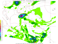
The NGM Model at 48 hours does show some impact for the Gulf Shores/Orange Beach area, but right now the risk of us experiencing tropical conditions remains marginal.

Tropical Depression Andrea?

As you can see, there is no consensus among the models. This storm is sloppy and disorganized, yet wind speeds are remaining consistant. Based on initial data this morning, it appears that sub-tropical storm Andrea has now become tropical depression Andrea, thus converting from a cold core system to a warm core system. (Click on the image to enlarge it.)

The 11:00am advisory from the National Hurricane Center will shed more light on this. Andrea’s future is in doubt, even as persistant of a little storm as she has been. Put simply, the odds are against her. If the NOGAPS and/or BAM models verify, then that would present Andrea with her best chance at survival. This mornings recon listed the wind speed at 39 knots which equals 44.85 (To figure it out the formula is: Knots X 1.15 = MPH)

Sub-Tropical Storm Andrea

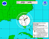
Tropical Storm Andrea (sub-tropical) has formed, creating the first named storm of the 2007 season. A tropical storm watch has been issued for much of the lower east coast and portions of Florida. This means that tropical storm conditions are likely within the next 36 hours.
Models vary on possible impact locations and overall track of this storm. At this time the storm is not expected to intensify much further, but on the same coin, it was not expected to become our first named storm.

The official advisory follows:

SUBTROPICAL STORM ANDREA ADVISORY NUMBER 1
NWS TPC/NATIONAL HURRICANE CENTER MIAMI FL
AL0120071100 AM EDT WED MAY 09 2007

…EARLY-SEASON SUBTROPICAL STORM FORMS OFF THE SOUTHEAST U.S.COAST…SATELLITE IMAGERY AND AIRCRAFT DATA INDICATE THAT THE LOW PRESSURESYSTEM OFF THE SOUTHEAST U.S. COAST HAS ACQUIRED SUBTROPICALCHARACTERISTICS.AT 11 AM EDT…1500 UTC…A TROPICAL STORM WATCH HAS BEEN ISSUEDALONG THE SOUTHEAST COAST OF THE UNITED STATES FROM ALTAMAHA SOUNDGEORGIA SOUTHWARD TO FLAGLER BEACH FLORIDA. A TROPICAL STORM WATCHMEANS THAT TROPICAL STORM CONDITIONS ARE POSSIBLE WITHIN THE WATCHAREA…GENERALLY WITHIN THE NEXT 36 HOURS.FOR STORM INFORMATION SPECIFIC TO YOUR AREA…INCLUDING POSSIBLEINLAND WATCHES AND WARNINGS…PLEASE MONITOR PRODUCTS ISSUEDBY YOUR LOCAL WEATHER OFFICE…http://www.nhc.noaa.gov/text/refresh/MIATC…ml/091443.shtml

Invest 90.L Prompting Warnings

Invest 90.L which at this time is more of a hybrid between a “cold core” storm like a Nor’Easter and a “warm core” storm like a hurricane, is generating tropical storm conditions for parts of North and South Carolina and Georgia. Most of the Eastern Seaboard is experiencing high surf.

This storm is not yet considered subtropical, but the NHC has scheduled a hunter flight and it could be designated “Andrea” by tomorrow. The path of the storm as projected by UKMET (see graphic) could bring it into the Gulf of Mexico later this week.

Invest 90.L — An Early Start

Let’s hope that this is not an indication to what we are looking at this season.

Global models are currently coming together for a possible sub-tropical/tropical system forming off of the Carolinas’ coastlines. Data from Station 41001 – (150 NM East of Cape HATTERAS) eports seas at 36+ feet and sustained winds just under 40 knots with stronger gusts. NHC has a floater over the storm, and further review is underway.

At this time, this system poses no threat to the Gulf Coast region. Video of the rotation can be found here: http://www.goes.noaa.gov/GSSLOOPS/ecwv.html

To be honest, this is a very unsual storm, and there could be the outside possibility that this becomes the first named storm of 2007.