Named Storm Sandy Recap

Tropical Storm Research Center Named Storm Sandy Recap:

While the storm is not finished as yet and many areas of the Caribbean and east coast of the US are hurting, we would just like to mention that this storm is one for the record books. It has had characteristics that have never been seen before in modern Meteorolgy. The storm was eventually graded as a Category 1 hurricane, but had the lowest barometric pressure of a northern Atlantic Coast landfall than any other storm in that region since records have been kept.

The cleanup is just commencing and the casualties from this storm, throughout it’s track, are great. As of this writing, just under100 persons have lost their lives and the toll is continuing to climb. We ask that you take a moment to pray for all victims of this terrible storm and to open your hearts to donate what you can to your favorite national help agency. The Red Cross and Salvation Army especially can use your help.

This is the last posting from TSRC regarding Named Storm Sandy, but the Tropical Storm season doesn’t end until the end of November. We are here, watching and analyzing, and will be back to post if any additional storms form in the Atlantic basin. Thank you for following our postings and thank you for advising your friends who may have been in harms way as to what was coming.

Tropical Storm Research Center, Gulf Shores, Alabama.

Hurricane Sandy

Hurricane Sandy is tied with being the 2nd largest storm ever in the Atlantic basin.

This video from the NOAA GOES Satellite shows the shear scale of “Frankenstorm”.

http://goes.gsfc.nasa.gov/goescolor/goeseast/hurricane2/movie/latest_ref.mov

Hurricane Preparedness –

Click on this text ballon for complete information:  We just wanted to remind everyone one last time that if you have friends or relatives who live near the Mid-Atlantic and New England areas who may not yet be aware of the Hurricane situation, to please try to contact them – Time is Running Out for preparedness. Please review the general information from NOAA listed below… Thank you.
 http://www.nhc.noaa.gov/prepare/hazards.php

Sandy Continues North

TAKE ACTION  NOW!

Based on current data, while Sandy is looking a bit rough around the edges after traversing the Caribbean,  however, this storm is steadily moving north.  Tracking along side the Eastern Seaboard of the U.S., Sandy is bringing the potential for a massive weather event.  Our models suggest that Sandy will make landfall in/near New England.

Of note, portions of the areas affected should expect to be without power with night-time temperatures below 30 degrees.  Additionally,  there is a low pressure system moving out of Canada that may interact with this system.  What this means, in short, could be something similar to the storm from 1991.    Caution and preparations should be rushed to completion in areas from North Carolina to Maine.

Several media outlets are already dubbing this weather system as a $1B storm, and if current model trajectories hold, I (personally) feel that said damages could well exceed that number.

HURRICANE SANDY Unofficial Advisory Wednesday, October 24, 5PM EDT

HURRICANE SANDY Unofficial Advisory Wed., October 24, 5 PM EDT.

As we mentioned in post number one, Named Storm Sandy has the potential to become more than just a nuisance. Many international tracking models including our own, are now showing a much more westerly potential, since a high pressure area off the central US coast will be blocking it’s northeasterly travel and will be moving the storm closer to the east coast of Florida, Georgia and the Carolinas over the next 2 to 5 days.

Because of the potential threat to many areas along the entire east coast of the United States, we are recommending that all persons from southern Florida to Maine monitor this storm carefully starting immediately. Persons may expect significant wave action, beach errosion, heavy rains, flooding in low coastal areas, power outages and possible tornadoes in the outer feeder bands.

The tracking models are changing hourly and this unofficial advisory is being offered as a precaution.

For up to the minute official advisories and information, please visit the NHC website in Miami:

http://www.nhc.noaa.gov/

We are also providing an interactive Watch and Warning web link for persons who wish to get details on localized conditions:

http://www.nws.noaa.gov/largemap.php

=============================================

“THIS IS NOT AN OFFICIAL ADVISORY. These updates and advisories are based upon information from our own computer models, NOAA, Local Weather Data Centers, deep water Buoy Data, and other publicly available sources. FOR THE SAFETY OF YOUR PROPERTY AND PERSON, please refer to your Local, State, and Federal Authority updates for Official Advisories and Orders. For up to the minute advisories and official updates, it is essential that you monitor your local Emergency Government, NOAA and Local Media Broadcasts. Please do not make personal safety decisions based upon information presented here in this Unofficial Advisory.”

Tropical Storm Research Center, Gulf Shores, Alabama –

http://www.wootaah.blogspot.com

============================================

PLEASE DO NOT POST REPLIES IN THIS THREAD

URGENT – PLEASE CLICK AND READ!!!!!

URGENT ADD-ON: FRIDAY OCTOBER 26, 2012 06:30 AM EDT:

From our Tropical Storm Research Center in Gulf Shores, Alabama – We are once again asking everyone who sees this memo to contact friends and family anywhere along the East Coast of the US to let them know about the severe possibilities regarding Hurricane Sandy. The most recent computer tracking models are showing significant involvement in the Mid Atlantic and New England states over the next 3 to 6 days. In addition to the official information available to you from the National Hurricane Center in Miami and the National Weather Service regionally please use our own web link for additional unofficial information. Thank you, and be safe.

http://wootaah.blogspot.com/

 +++++++++++++++++++++++++++++++++++++++++++++++++++++++++++++++++++++++

Our Tropical Storm Research Center normally does not post unofficial advisories until a storm in the Tropics is named. However, this is a rare exception.

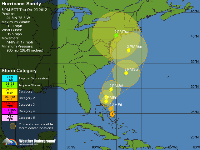
Tropical Depression Eighteen, soon to be a named storm (probably Sandy) developed in the central Caribbean over the past 4 days. This storm is currently nearly stationary which is allowing it to develop rapidly. The steering currents will start moving this storm to the north-northeast and it will be affecting southern Florida with some thunderstorms and gusty winds in a couple days.

The reason that we are posting early information is because one of the better tracking models is showing an interaction with an inland surface low pressure area forming over the Tennessee and Ohio Valleys. The tracking model that we are concerned about is showing a merge of these two storms off the central East Coast of the US and may affect areas from Virginia to Maine over the next 5 to 9 days. If this storm stays fairly close to the US coastline, it could become a very strong ‘noreaster’ as it approaches New England. We are suggesting that all persons from southern Florida to Maine monitor the status of this storm in case the tracking model that is showing this possibility is as accurate as we think that it may be.

For up to the minute official advisories and information, please visit the NHC website in Miami:

http://www.nhc.noaa.gov/

We are also providing an interactive Watch and Warning web link for persons who wish to get details on localized conditions:

http://www.nws.noaa.gov/largemap.php

=============================================

“THIS IS NOT AN OFFICIAL ADVISORY. These updates and advisories are based upon information from our own computer models, NOAA, Local Weather Data Centers, deep water Buoy Data, and other publicly available sources. FOR THE SAFETY OF YOUR PROPERTY AND PERSON, please refer to your Local, State, and Federal Authority updates for Official Advisories and Orders. For up to the minute advisories and official updates, it is essential that you monitor your local Emergency Government, NOAA and Local Media Broadcasts. Please do not make personal safety decisions based upon information presented here in this Unofficial Advisory.”

Tropical Storm Research Center, Gulf Shores, Alabama –

http://www.wootaah.blogspot.com

============================================

Tropical Storm/Depression Patty and Invest 98L

In keeping with our policy to at least mention all storms named by the National Hurricane Center, we are doing just that. Tropical Storm Patty – now Tropical Depression Patty – formed and shortly thereafter weakend back into a Tropical Depression. This storm is being torn apart southwest to northeast between Cuba and Bermuda by a strong jet stream aloft and surface high pressure. This storm will bring some rainfall to southern Florida over the next week or so. We are also monitoring an area of low pressure near rhe Windward Islands that will be moving northerly in the next few days. This may become a Tropical Storm (Rafael) and will most likely be affecting Bermuda in a week or so and then move into the north central Atlantic. This will be our only mention of these two storms UNLESS a significant tracking change is indicated.

For up to the minute official advisories and information, please visit the NHC website in Miami:

http://www.nhc.noaa.gov/

We are also providing an interactive Watch and Warning web link for persons who wish to get details on localized conditions:

http://www.nws.noaa.gov/largemap.php

=============================================

“THIS IS NOT AN OFFICIAL ADVISORY. These updates and advisories are based upon information from our own computer models, NOAA, Local Weather Data Centers, deep water Buoy Data, and other publicly available sources. FOR THE SAFETY OF YOUR PROPERTY AND PERSON, please refer to your Local, State, and Federal Authority updates for Official Advisories and Orders. For up to the minute advisories and official updates, it is essential that you monitor your local Emergency Government, NOAA and Local Media Broadcasts. Please do not make personal safety decisions based upon information presented here in this Unofficial Advisory.”

Tropical Storm Research Center, Gulf Shores, Alabama –

http://www.wootaah.blogspot.com

============================================

Named Storm Oscar

Tropical Storm Oscar formed in the east central Atlantic from a tropical wave on Wednesday. This storm will be pushed to the northeast quickly by the upper level features present just to the north of the storm and will not affect any US coastal interests. This will be our only mention of named storm Oscar.

For up to the minute official advisories and information, please visit the NHC website in Miami:

http://www.nhc.noaa.gov/

We are also providing an interactive Watch and Warning web link for persons who wish to get details on localized conditions:

http://www.nws.noaa.gov/largemap.php

=============================================

“THIS IS NOT AN OFFICIAL ADVISORY. These updates and advisories are based upon information from our own computer models, NOAA, Local Weather Data Centers, deep water Buoy Data, and other publicly available sources. FOR THE SAFETY OF YOUR PROPERTY AND PERSON, please refer to your Local, State, and Federal Authority updates for Official Advisories and Orders. For up to the minute advisories and official updates, it is essential that you monitor your local Emergency Government, NOAA and Local Media Broadcasts. Please do not make personal safety decisions based upon information presented here in this Unofficial Advisory.”

http://www.wootaah.blogspot.com

============================================

Update on Named Storm Nadine October 03, 2012

Update on Named Storm Nadine.  This storm area has gone into the records as one of the longest lasting active named storms since it became a named storm on September 21.  It has tracked across itself a number of times and is relatively stationary in the east central Atlantic today. This storm will move with the upper level jet stream and other upper level currents for several days yet and will slowly dissipate.