Very Early Heads Up – June 28, 2014 – US Southeast

Just a very early heads up… We are tracking a slow moving low pressure area off the coasts of South Carolina and Georgia. It is not moving very quickly at this time because it is associated with a stationary front, but once we get into early this coming week, it has potential to develop into a Tropical Depression and move back across northern Florida into the Gulf of Mexico. This has only a 10 to 20 percent possibility at this time, but it still should be watched. There is another weather system in the general area that may prevent development of this low, however we will keep on top of this and provide updates if needed.

Tropical Storm Research Center Staff –

Content Copyright TSRC 2014, All Rights Reserved.

The Start of Tropical Storm and Hurricane Season, 2014

The official Tropical Storm and Hurricane Season runs from June 01 through November 30 each year. The Tropical Storm Research Center volunteer staff has analyzed, tracked, evaluated and posted ‘unofficial’ advisories and updates on all named Tropical Storms and Hurricanes since 2006.  Our record regarding storm tracks, landfall intensities and locations has been a bit more accurate than some official reporting agencies.

With the 2014 Tropical Storm and Hurricane Season at hand, we have already been evaluating potential storm development in the Atlantic, Caribbean and Gulf of Mexico for several weeks. Our computer modeling software is running and we are ready to help you keep yourself and your family advised, unofficially, in the face of these devastating storms. We hope that you used the link that we provided to the National Hurricane Center “Preparedness Week” website. If you wish to review the information presented there, the link can be found in the posting just below this one.

The Tropical Storm Research Center volunteer staff is on the job and watching. We will post information on all named storms and thank you for following us here at gulfstorm.net . Take care and Be Safe.

DSCN1171

Hurricane Season Preparation 2014

Each year we request that our viewers, who reside in or have interests in Tropical Storm and Hurricane prone areas, use our supplied links to review season preparedness recommendations.

National Hurricane Preparedness Week 2014 runs from May 25th through May 31st. We are providing links to valuable pre season resources to keep your family safe. Please review the information in this link below and check back with us periodically during May for additional information and helpful suggestions.

LINK to NOAA Preparation Site >>>

http://www.nhc.noaa.gov/prepare/

For INLAND storm information year round, please click on the BLOG button, top right of this page and then click on the Interactive Weather Map link that is provided.

For a list of state by state Emergency Management and Operations Centers, please use the following link:

http://www.fema.gov/state-offices-and-agencies-emergency-management

Thank you.

TSRC Staff

image001


Weather Information for May 06 to May 11, 2014

A moderate low pressure area, currently off the Washington State and Oregon coast, will be moving across the Rocky Mountains this weekend and will start to draw energy from Gulf of Mexico moisture. The wind patterns aloft and at the surface will most likely create conditions where convection (atmospheric lifting) will take place and with cold air to the north of the low and hot, humid air to the south, significant thunderstorm activitiy may form in the central Plains States as well as the Midwest early this week and extend into next weekend. While it is too early to predict severity, the computer modeling is showing an increasing potential this coming week for significant thunderstorm activity and the possibility of more tornadoes in some of the same central plains areas affected last week.

If you have interests in these areas, please watch your local media and the National Weather Service for official advisories and updates. Use this link for details on INLAND weather issues for the United States:

http://www.nws.noaa.gov/largemap.php

=============================================

“THIS IS NOT AN OFFICIAL ADVISORY. These updates and advisories are based upon information from our own computer models, NOAA, Local Weather Data Centers, deep water Buoy Data, and other publicly available sources. FOR THE SAFETY OF YOUR PROPERTY AND PERSON, please refer to your Local, State, and Federal Authority updates for Official Advisories and Orders. For up to the minute advisories and official updates, it is essential that you monitor your local Emergency Government, NOAA and Local Media Broadcasts. Please do not make personal safety decisions based upon information presented here in this Unofficial Advisory.”

Tropical Storm Research Center, Gulf Shores, Alabama.

TSRC Link >>> www.gulfstorm.net

============================================

Hurricane Season Preparation 2014

Each year we request that our viewers, who reside in or have interests in Tropical Storm and Hurricane prone areas, use our supplied links to review season preparedness recommendations.

National Hurricane Preparedness Week 2014 runs from May 25th through May 31st. We are providing links to valuable pre season resources to keep your family safe. Please review the information in this link below and check back with us periodically during May for additional information and helpful suggestions.

LINK to NOAA Preparation Site >>>

http://www.nhc.noaa.gov/prepare/

For INLAND storm information year round, please click on the BLOG button, top right of this page and then click on the Interactive Weather Map link that is provided.

Thank you.

TSRC Staff

image001


Important Severe Storm Information for April 25 to April 30, 2014

There is a significant severe inland weather situation developing for the Southern Plains States, the Deep South and Southeast over the next few days. Weather analysis is showing a potential for severe storms, high winds, hail and some long track tornadoes extending from northeastern Texas, Oklahoma and Kansas from late Friday into Sunday. These storms will move easterly over the weekend and will also be affecting Louisiana, Arkansas, Missouri, southern Illinois, Kentucky, Tennessee, Alabama, Mississippi, northwestern Florida and Georgia through Tuesay,  April 29.  The storms will then continue to track into southeastern and east central Atlantic coastal areas on Wednesday and Thursday.  Persons in these areas should monitor your local media and National Weather Service broadcasts for alerts, watches and warnings. You may also use the interactive link to the NWS weather alert system by clicking on the link located in the BLOG area, top right navigation bar on this page.

While our TSRC office normally does not post inland storm details, this situation is an exception since a significant tornado threat is developing over such a wide area.


2014 May see El Nino Effect

Warmer than normal Pacific Ocean

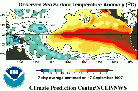
The NWS and NOAA are predicting a greater than 50% chance of an El Nino effect, which means warmer water temperatures in the Pacific Ocean and cooler than normal water temperatures in the Atlantic Ocean.  During El Nino, we typically have fewer tropical systems in the Atlantic and in the Gulf of Mexico.  In 1992, there was an El Nino event, and only 7 storms formed, however, one of those seven was Hurricane Andrew.

Off Season Interactive Link

Marco Island Florida storm 40 minutes after sunset

Welcome to gulfstorm.net, the interactive website of the
Tropical Storm Research Center  with regional offices in Gulf Shores, Alabama, and Green Bay, Wisconsin.

Our primary responsibility is to provide information during the Tropical Storm season each June through November. However, we are providing a link below to the National Weather Service interactive weather map in the event that you have concerns about inland weather in your area. Click on the link below OR copy and paste the link into your browser. Then click on your area on the map for interactive information.

http://www.nws.noaa.gov/largemap.php

You can also click on the BLOG button in the navigation bar at the top right of this page for regional and local details.