Tropical Storm Fay Advisory 20:00 Hrs CDT, 22 August 2008

This unofficial advisory is being posted from data provided by WKRG TV Channel 5 and other sources.
Baldwin County officials are preparing shelters for residents in low lying areas. The following shelters will be opening at 18:00 Hrs. (6 PM) Saturday, 23 August:

-Fairhope Satellite Courthouse.
-Foley Satellite Courthouse.
-Baldwin County Level 2 Shelter on N. White Avenue in Bay Minette.

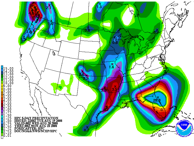
Persons along the Fish and Styx Rivers in Baldwin County may be some of the first persons who will need to move to higher ground or to the shelters. As slow as Fay is moving, the rainfall totals could be close to those experienced with Hurricane Ivan in September of 2004. Mobile County has mobilized their High Water Rescue Teams and have them staged at strategic locations.

Some rain bands have already come through the South Baldwin County region with more on the way for the overnight hours. For those with Weather Alert Radios on the NOAA alert network, listen carefully for watches and warnings as well as monitoring your local media stations. Use the first link below for Tropical Storm information and the second link below for interactive watches and warnings.

http://www.nhc.noaa.gov/

http://www.weather.gov/largemap.php

================================================== =======
“THIS IS NOT AN OFFICIAL ADVISORY. These updates and advisories are based upon information from our own computer models, NOAA, Local Weather Data Centers, deep water Buoy Data, and other publicly available sources. FOR THE SAFETY OF YOUR PROPERTY AND PERSON, please refer to your Local, State, and Federal Authority updates for Official Advisories and Orders. For up to the minute advisories and official updates, it is essential that you monitor your local Emergency Government, NOAA and Local Media Broadcasts. Please do not make personal safety decisions based upon information presented here in this Unofficial Advisory.”
================================================== =======

Models are going crazy


With a 700 + mile cone, the NHC forecast is mired in uncertainty about T.S. Fay. Her maximum sustained winds are at 60 MPH, and is slowly moving westward dropping massive amounts of rain. Click on the image to enlarge it.

The graphic illustrates the confusion in the models, and strongly indicates that our area will feel the effects of Fay after all.

Fay is is bringing rain

TS Fay’s westward shift appears to have begun. Thankfully, Fay will not be over water for much of her future. Unfortunately, she appears to be headed our way with copius amounts of rain. Flooding, especially in areas such as Santa Rosa County (FL) Escambia County (FL), and Baldwin County (AL) reamins a very real threat.

Rainfall amounts could range from 10 inches to over 18 inches. For our area, should the models verify, I would expect 6-8 inches of rain.

Invest 94L is marching to the west, but has shear and the SAL to contend with over the next few days. Rapid development is not expected, and there is a good chance that the shear and dry air will preclude any development.

Remote Data Backups

The models are still nuts


Some data as well as imagery suggest that Fay may be stalling, and if so, rainfall could be measured in feet as opposed to inches.

It is starting to appear that our area may very well feel the effects of Fay, yet not in the manner I had thought. This is a very strange storm. This afternoon she appeared to be intensifying, but starting to look pretty rough at the time of this writing. On several sites, the thought from both amatuers such as myself and professional climatologists and meteorologists is “Fay go away and give us something we can make sense of.

We have Noodles


Fay is still driving the models nuts, and I am proud to say that I WAS WRONG. The High is shoving Fay to the east, yet the models are bound and determined shove her back west even over north Alabama.

She has maintained her northerly track and does not have much potential in the way of intensification as long as she stays on her current path. A plus can be drawn in that she holds the potential to bring much needed relief to draught areas.

Fay is a killer. She is not done yet. Stay safe and vigilant, but for our area, the immediate threat is all but over.

Shear and Highs

Fay has both, some wind shear and a High pressure system that is trying to keep her timid and push her to the east. The GFDL and GFS models toss her over the Florida Peninsula whereas the BAMS and NOGAPS bring her to our neck of the woods.

She appears to be showing a straight northerly movement which is very good for our area, and Florida in that her time over water will be significantly reduced. The key will be over the next 36 hours, to see where she takes aim. She remains a small storm, and appears to be showing signs of intensifying, but I don’t think she will become a major hurricane before landfall based on current data.

All of that can change in a matter of hours, but for now, our set up is looking better and better for us.

Fay has trouble


The mountainous regions of Cuba may destroy Fay, but I doubt it.

The bath water we have discussed is still there and Fay is growing. She has an impressive anti-cyclone with her which allows her to vent energy as she creeps westward. Our cone of impact is edging towards the Florida panhandle, parts of Mississippi and Alabama should watch this system.

Fay has been stubborn and is determined to make a name for herself. She still has some obstacles to overcome, and that will be the telling. Another update inside of 12 hours.

Tropical Cyclone Fay


According to internal reports from the U.S. Navy and the NHC, Tropical Cyclone Fay has formed. We expect an official 5-day cone at the 5pm EDT report from the National Hurricane Center.

Models continue to suggest that Fay will emerge into the Gulf of Mexico with the potential to become a major hurricane. At the early juncture, wild speculation could put Fay anywhere from Mississippi to the Florida coast line. New models are being ran, and I’ll have more information later today.

The NHC headers are:

293
WHXX01 KWBC 152000
CHGHUR
TROPICAL CYCLONE GUIDANCE MESSAGE
NWS TPC/NATIONAL HURRICANE CENTER MIAMI FL
2000 UTC FRI AUG 15 2008

DISCLAIMER…NUMERICAL MODELS ARE SUBJECT TO LARGE ERRORS.
PLEASE REFER TO NHC OFFICIAL FORECASTS FOR TROPICAL CYCLONE
AND SUBTROPICAL CYCLONE INFORMATION.

ATLANTIC OBJECTIVE AIDS FOR

TROPICAL CYCLONE FAY (AL062008) 20080815 1800 UTC