Sub Tropical Storm Beryl – 2012

Sub Tropical Storm Beryl formed from a low pressure area off the coast of South Carolina overnight. This storm was assigned a name by the National Hurricane Center because of the potential for high wave action, tropical storm force winds and heavy rains. The storm is moving east southeast and will be impacting north eastern Florida, Georgia and South Carolina by day’s end with actual landfall later Sunday evening, May 27. Once this storm makes landfall, it will start to be directed back to the north east by an upper level system and will be downgraded to a subtropical depression and then a low pressure area by mid week. Persons in coastal north eastern Florida, Georgia and South Carolina can expect high wave action, strong rip currents, gusty winds, heavy rain in some areas and some lowlands coastal flooding. Since this storm is sub tropical in nature, this will be our only reporting of Named Storm Beryl.

For up to the minute official advisories and information, please visit the NHC website in Miami:

http://www.nhc.noaa.gov/

We are also providing an interactive Watch and Warning web link for persons who wish to get details on localized conditions:

http://www.nws.noaa.gov/largemap.php

=============================================

“THIS IS NOT AN OFFICIAL ADVISORY. These updates and advisories are based upon information from our own computer models, NOAA, Local Weather Data Centers, deep water Buoy Data, and other publicly available sources. FOR THE SAFETY OF YOUR PROPERTY AND PERSON, please refer to your Local, State, and Federal Authority updates for Official Advisories and Orders. For up to the minute advisories and official updates, it is essential that you monitor your local Emergency Government, NOAA and Local Media Broadcasts. Please do not make personal safety decisions based upon information presented here in this Unofficial Advisory.”

http://www.wootaah.blogspot.com

============================================

PLEASE do not post replies in Named Storm Threads. Thank You.

Named Storm Alberto

Tropical Storm Alberto formed from a low pressure area off the Georgia / South Carolina coast overnight. While the official start of the Atlantic Basin Tropical Storm Season doesn’t begin until June 01, the National Hurricane Center in Miami named this storm because of it’s tropical characteristics. Alberto will follow the Atlantic Coast of the US and will produce gusty winds, heavy pockets of rain with some coastal flooding possible from South Carolina to the Del-Mar-Va area by mid week. Since this storm has very little chance of intensifying, this will be our only post for this Tropical Storm.

For up to the minute official advisories and information, please visit the NHC website in Miami:

http://www.nhc.noaa.gov/

We are also providing an interactive Watch and Warning web link for persons who wish to get details on localized conditions:

http://www.nws.noaa.gov/largemap.php

=============================================

“THIS IS NOT AN OFFICIAL ADVISORY. These updates and advisories are based upon information from our own computer models, NOAA, Local Weather Data Centers, deep water Buoy Data, and other publicly available sources. FOR THE SAFETY OF YOUR PROPERTY AND PERSON, please refer to your Local, State, and Federal Authority updates for Official Advisories and Orders. For up to the minute advisories and official updates, it is essential that you monitor your local Emergency Government, NOAA and Local Media Broadcasts. Please do not make personal safety decisions based upon information presented here in this Unofficial Advisory.”

http://www.wootaah.blogspot.com

============================================

2012 Atlantic Tropical Storm Season

As June 1st slowly approaches, the staff at the Tropical Storm Research Center in Gulf Shores, Alabama, is gearing up for computer modeling and analysis of active storms. While some researchers are calling for lower than normal activity level for the upcoming season, we at TSRC do not predict future storm possibilities. We analyze current storms and monitor tracks. We post UNOFFICIAL advisories in this blog as well as in 8 discussion forums with viewers in the Gulf Coast and Atlantic Coast areas. Predicting storm activity is an imprecise science and while intentions may be admirable, the predictions are rarely accurate enough to be within the Margin of Error statistically.

We will provide a link below to the NHC Hurricane Preparedness Site. This is a valuable information link for everyone who lives near the south and east coasts of the US. Hurricane Awareness Week is May 27 to June 02, 2012.

CLICK >>> http://www.nhc.noaa.gov/prepare/

As the start of the season gets closer, please check this blog frequently for Unofficial info and advisories.

Thank you and Be Safe.

For up to the minute official advisories and information, please visit the NHC website in Miami:

http://www.nhc.noaa.gov/

=============================================

“THIS IS NOT AN OFFICIAL ADVISORY. These updates and advisories are based upon information from our own computer models, NOAA, Local Weather Data Centers, deep water Buoy Data, and other publicly available sources. FOR THE SAFETY OF YOUR PROPERTY AND PERSON, please refer to your Local, State, and Federal Authority updates for Official Advisories and Orders. For up to the minute advisories and official updates, it is essential that you monitor your local Emergency Government, NOAA and Local Media Broadcasts. Please do not make personal safety decisions based upon information presented here in this Unofficial Advisory.”

http://www.wootaah.blogspot.com

============================================

Possible Significant Weather Event for Alabama

Models are increasingly hinting at a severe weather event for most of Alabama leading into this Thursday and culminating Friday with extreme southern Alabama. Early models suggest Thursday’s greatest risk will include north and central Alabama, and Friday’s risk will be for the coastal regions of Alabama and Florida and moving into Georgia.

If the models continue to maintain agreement, I will update within 24 hours.

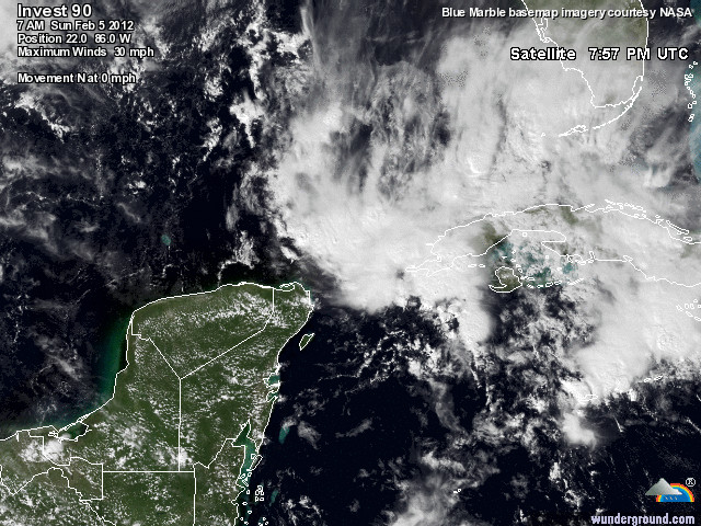
Invest 90L – Yes, in February


Dr. Jeff Masters said, “This is nuts.” Be it as it may, conditions are marginally favorable for continued development. Invest 90L should bring some impact to south-western Florida later in the week, and probably will not achieve Tropical Storm status, but there is a chance it could become a Tropical Depression.

Winter Weather in Alabama, a church rises up

http://www.abc3340.com/story/16602547/church-serving-storm-survivors

Many people do not realize that there are two “tornado seasons” in the deep south, and those seasons are not far apart. Conditions are conducive around the Christmas season and also (most widely noted) in the spring. The areas affected by the April 27th storms were slammed again only a scant eight months later. Of note, this did not occur in the April 3, 1974 outbreak. By way of comparison, Hurricane Ivan struck Gulf Shores and Orange Beach dead on. Pensacola, Atmore, Evergreen, Greenville… they got rocked hard. Ivan hit on September 16, 2004. If you drive of the “beaten path” today in Gulf Shores, Perdido Key, or Pensacola, the echoes of that monster are still here. Those wounds are healing, that Ivan is now 8 years gone.
Jefferson County got mauled TWICE in under a year. Joplin, Tuscaloosa, and of course Birmingham face a long road to recovery, but they will make it. Pass Christian, New Orleans, Biloxi, Pasagoula, and all other areas devastated by Katrina are making it. Spring is coming, so as always, we need to keep watchful eyes to the skies.
What is frustrating to many atmospheric scientists, meteorologist, storm chasers, and many others, is that most people do not heed the warnings. “It will never happen to me.” is a common denominator. We all seem to lose sight of one simple truth: It is not “if”, it is “when”. I hope that you understand the fact that it is “when”.
If you are reading this blog, then please get an app for your smartphone with weather alerts or better yet, get a NOAA Weather Radio.
This was an EF3, and you can see the damge in this video: http://www.youtube.com/watch?v=DJgsm7_nP8A

2011 Hurricane Season Ends November 30

While the official end of the 2011 Hurricane Season is November 30, we are just offering a season ending recap. First of all, thank you for following our postings this year. Our volunteer team of Tropical Storm System analysts has devoted countless hours in detailing, tracking and projecting this season’s Tropical Storm activity to try our best to keep our viewers safe and informed. We are relieved that the storm involvement on the coastal US was relatively minor as compared to previous years. We will continue to monitor things well into December and if any late season systems develop, we will be back to post updates.

Our team will once again refine our detailed software in the off-season and we will be back in early May, 2012, to start posting Tropical Storm and Hurricane Preparedness information in the pre-season. Thank you again, take care and be safe.

Hurricane Rina Update October 25

HURRICANE RINA was upgraded to Category 2 storm overnight and will most likely reach Major category within 24 hours, but the upper level shear and dry air that the storm will be encountering soon will change the track of the storm into an area where additional strengthening may be limited. However, persons in the south half of Florida should be watching this storm’s progress because even as a weakening storm – there could be huge amounts of rain and potential lowlands flooding this weekend and into early November.

For up to the minute official advisories and information, please visit the NHC website in Miami:

http://www.nhc.noaa.gov/

=============================================

“THIS IS NOT AN OFFICIAL ADVISORY. These updates and advisories are based upon information from our own computer models, NOAA, Local Weather Data Centers, deep water Buoy Data, and other publicly available sources. FOR THE SAFETY OF YOUR PROPERTY AND PERSON, please refer to your Local, State, and Federal Authority updates for Official Advisories and Orders. For up to the minute advisories and official updates, it is essential that you monitor your local Emergency Government, NOAA and Local Media Broadcasts. Please do not make personal safety decisions based upon information presented here in this Unofficial Advisory.”

http://www.wootaah.blogspot.com

============================================

Named Storm Rina

Tropical Storm Rina developed in the west central Caribbean Sea over the weekend. This storm is encountering upper level wind shear, however, it is nearly stationary which means that the shear will move out of the area in a few days while leaving the potential for this storm to increase in intensity later this week. Some of the NHC tracking models are showing a western Florida involvement sometime close to Nov. 02 to Nov. 04. Other models are showing that this storm will turn westerly and dissipate over the land areas of eastern Mexico. It is much too early to project accurate tracking past this Saturday, October 29, but we will post any information as it becomes available.

For up to the minute official advisories and information, please visit the NHC website in Miami:

http://www.nhc.noaa.gov/

=============================================

“THIS IS NOT AN OFFICIAL ADVISORY. These updates and advisories are based upon information from our own computer models, NOAA, Local Weather Data Centers, deep water Buoy Data, and other publicly available sources. FOR THE SAFETY OF YOUR PROPERTY AND PERSON, please refer to your Local, State, and Federal Authority updates for Official Advisories and Orders. For up to the minute advisories and official updates, it is essential that you monitor your local Emergency Government, NOAA and Local Media Broadcasts. Please do not make personal safety decisions based upon information presented here in this Unofficial Advisory.”

http://www.wootaah.blogspot.com

============================================

TS Ophelia and TS Philippe Final Info

Final Tropical Storm Ophelia – and Tropical Storm Philippe information.

As anticipated, TS Ophelia will remain well off the east coast of the US and will not bring anything but slightly higher surf conditions to some areas next week. We will not be tracking Tropical Storm Philippe at all because the storm will move northward and will stay well out to sea in the central Atlantic.

For up to the minute official advisories and information, please visit the NHC website in Miami:

http://www.nhc.noaa.gov/

We are also providing an interactive Watch and Warning web link for persons who wish to get details on localized conditions:

http://www.nws.noaa.gov/largemap.php

=============================================

“THIS IS NOT AN OFFICIAL ADVISORY. These updates and advisories are based upon information from our own computer models, NOAA, Local Weather Data Centers, deep water Buoy Data, and other publicly available sources. FOR THE SAFETY OF YOUR PROPERTY AND PERSON, please refer to your Local, State, and Federal Authority updates for Official Advisories and Orders. For up to the minute advisories and official updates, it is essential that you monitor your local Emergency Government, NOAA and Local Media Broadcasts. Please do not make personal safety decisions based upon information presented here in this Unofficial Advisory.”

http://www.wootaah.blogspot.com

============================================