Sub-Tropical Storm Andrea
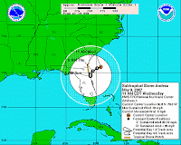
Models vary on possible impact locations and overall track of this storm. At this time the storm is not expected to intensify much further, but on the same coin, it was not expected to become our first named storm.
The official advisory follows:
SUBTROPICAL STORM ANDREA ADVISORY NUMBER 1
NWS TPC/NATIONAL HURRICANE CENTER MIAMI FL
AL0120071100 AM EDT WED MAY 09 2007
…EARLY-SEASON SUBTROPICAL STORM FORMS OFF THE SOUTHEAST U.S.COAST…SATELLITE IMAGERY AND AIRCRAFT DATA INDICATE THAT THE LOW PRESSURESYSTEM OFF THE SOUTHEAST U.S. COAST HAS ACQUIRED SUBTROPICALCHARACTERISTICS.AT 11 AM EDT…1500 UTC…A TROPICAL STORM WATCH HAS BEEN ISSUEDALONG THE SOUTHEAST COAST OF THE UNITED STATES FROM ALTAMAHA SOUNDGEORGIA SOUTHWARD TO FLAGLER BEACH FLORIDA. A TROPICAL STORM WATCHMEANS THAT TROPICAL STORM CONDITIONS ARE POSSIBLE WITHIN THE WATCHAREA…GENERALLY WITHIN THE NEXT 36 HOURS.FOR STORM INFORMATION SPECIFIC TO YOUR AREA…INCLUDING POSSIBLEINLAND WATCHES AND WARNINGS…PLEASE MONITOR PRODUCTS ISSUEDBY YOUR LOCAL WEATHER OFFICE…http://www.nhc.noaa.gov/text/refresh/MIATC…ml/091443.shtml
Invest 90.L Prompting Warnings
 iencing high surf.
This storm is not yet considered subtropical, but the NHC has scheduled a hunter flight and it could be designated “Andrea” by tomorrow. The path of the storm as projected by UKMET (see graphic) could bring it into the Gulf of Mexico later this week.
Invest 90.L — An Early Start
Let’s hope that this is not an indication to what we are looking at this season.
Global models are currently coming together for a possible sub-tropical/tropical system forming off of the Carolinas’ coastlines. Data from Station 41001 – (150 NM East of Cape HATTERAS) eports seas at 36+ feet and sustained winds just under 40 knots with stronger gusts. NHC has a floater over the storm, and further review is underway.
At this time, this system poses no threat to the Gulf Coast region. Video of the rotation can be found here: http://www.goes.noaa.gov/GSSLOOPS/ecwv.html
To be honest, this is a very unsual storm, and there could be the outside possibility that this becomes the first named storm of 2007.
2007 Nor’easter
The Lows are converging now. Numerous wind, surf, flood, and marine advisories in effect. This looks to be verifying.
For the conditions, consider it to be like a Cat One Hurricane. Fears that that it and the surge will pass over New York City at high tide. Looks to be every bit as dangerous as “The Perfect Storm” or the “Storm of the Century”. Flooding is a real concern for New York, including Long Island. Pressure is at 968 MB and falling.
One email I got from a resident in New York said “This is not funny any more, and it’s not even here yet.”
One storm tracking in this system is moving at a whopping 105 miles per hour.
Our area remains under a high wind advisory as the actual front moves through today.
The show has begun
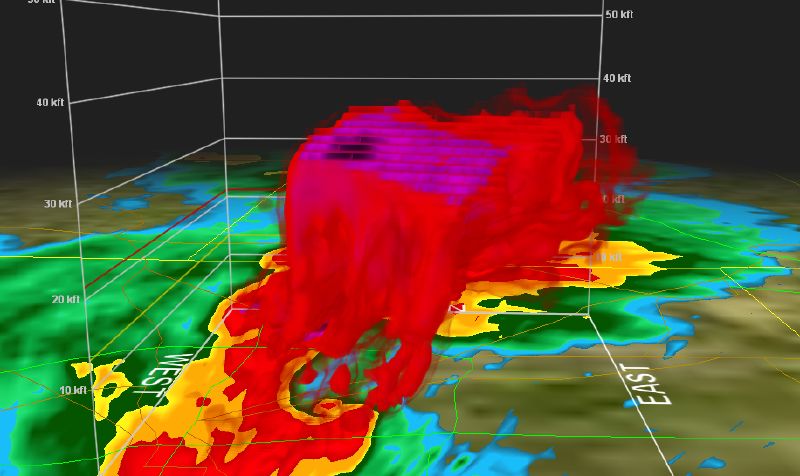
This image reflects the supercell that moved through the Dallas/Ft. Worth area earlier this evening.
Minor to moderate damage has been reported based on initial estimates. The NWS expects this line of storms to affect those in the Mississippi Valley and Tennessee Valley areas, and should provide a moderate to high risk for severe weather. Some forecasters are pridicting as much as 2″ hail even along the coastal areas.
As mentioned in an earlier entry, the activity poses a significant, if not imminent, threat for severe weather. A station out of Dallas confirmed initial damage but was unable to determine if said damage was from straight line winds or tornadic activity. In a brief moment of levity, I propose that if our houses are damaged/destroyed, we really are not going to care whether it was a funnel or straight line. Seriously, a long tracking Supercell storm will produce both, and often it is important to note and track both events.
Get you NOAA radios and make sure the batteries are good, as this has the potential to be a long night for many of us.
Severe Weather Statement 4/13 – 4/14
There remains the potential for widespread severe weather for the Eastern half of the United States, for today and through the weekend.
Basically, there are three storm systems converging which will create a “Nor’easter”, possible similar to the event detailed in the movie “A Perfect Storm”. The eastern half of the U.S. will be affected, most of the area will be looking at gale force winds, beach erosion, and heavy snowfall. In OUR area, we will be looking at high winds, possibility of long tracking super-cell thunderstorms, hail, and tornados.
At the time of this writing, much of Texas is under a Tornado Watch and High Wind Advisory, with a couple of counties under a Tornado WARNING.
The threat for us should materialize later tonight and throughout the day tomorrow.
2007 Hurricane Predictions
Dr. William Gray has released his teams predictions for the 2007 Hurricane Season. The long and short of it is: 17 named storms, with 5 major storms. (A major storm is a hurricane with sustained winds in excess of 111 mph.)
Last year, from NOAA to AccuWeather, the hurricane pre-season forecast was a bust. The reason for this was the El Nino event in the Pacific Basin. That should not be a factor this year, hence Dr. Gray’s estimate that there is a 74% chance of a major hurricane making landfall on the U.S. coast.
For the Gulf Shores area, history shows us that our peak activity and risk for landfall has traditionally been in September.
As you know, the names are rotated, with particularly devasting storms having their name “retired”. For this season the names are:
Andrea
Barry
Chantal
Dean
Erin
Felix
Gabrielle
Humberto
Ingrid
Jerry
Karen
Lorenzo
Melissa
Noel
Olga
Pablo
Rebekah
Sebastien
Tanya
Van
Wendy


