Wet Weather – July 2013

The NHC gives an area of Low Pressure near the Bay of Campeche a 10% chance of developing.  None of the models develop this system, but there is an outlier chance of some development before low moves inland near the Texas/Mexico border.

Elsewhere, a trough has established itself of much of the Central and Eastern United States.  Near the Gulf of Mexico, along the Mississippi, Alabama, and Florida coasts, the area of disturbed weather is exhibiting some tropical characteristics.  While severe weather is not expected to be widespread, heavy rainfall, localized flash flooding, and dangerous rip currents are a distinct possibility now through Friday.  Additionally, the cities of Orange Beach and Guld Shores are flying the purple flags which indicate dangerous marine life, in this case, jellyfish and stingrays are the culprits.  Those of you enjoying the Fourth of July along the Gulf Coast, have a good time and stay safe out there.

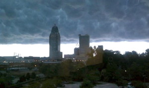
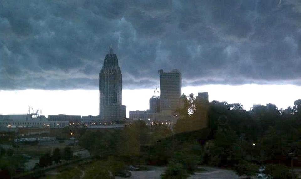
This photo is of Mammatus clouds over the Mobile, Alabama skyline last year.  Over the next few days, we may see more of these.

Tropical Storm Barry – 2013

Tropical Storm Barry formed in the southern Gulf of Mexico from a tropical depression. The storm has very little chance of intensifying and will be over land in eastern Mexico within 24 hours. Since this storm will not be affecting coastal US, this will be our only mention of Tropical Storm Barry.

Use this interactive link to check all conditions in your own area:

http://www.nws.noaa.gov/largemap.php

For up to the minute official advisories and information, please visit the NHC website in Miami:

http://www.nhc.noaa.gov/

=============================================

“THIS IS NOT AN OFFICIAL ADVISORY. These updates and advisories are based upon information from our own computer models, NOAA, Local Weather Data Centers, deep water Buoy Data, and other publicly available sources. FOR THE SAFETY OF YOUR PROPERTY AND PERSON, please refer to your Local, State, and Federal Authority updates for Official Advisories and Orders. For up to the minute advisories and official updates, it is essential that you monitor your local Emergency Government, NOAA and Local Media Broadcasts. Please do not make personal safety decisions based upon information presented here in this Unofficial Advisory.”

Tropical Storm Research Center, Gulf Shores, Alabama.

http://www.wootaah.blogspot.com

============================================

Named Storm Andrea – 2013

The National Hurricane Center in Miami has named Tropical Storm Andrea in the central Gulf of Mexico. This storm is a minimal Tropical Storm, but persons living along the Gulf Coast of Florida from Marco Island to Apalachicola can anticipate a 2 to 4 foot storm surge, heavy rains, beach erosion and tropical storm force winds for most of Thursday, June 06. This storm will make first landfall near Cedar Key, Florida, Thursday afternoon and will track across northern Florida and enter the Atlantic coastal areas of Georgia and South Carolina on Friday, June 07. The storm will track up the east coast causing on-shore gusty winds, heavy rains, rip currents, beach erosion and some tornadoes. It will be off the coast of New England and the Maritime Provinces of Canada late Saturday, June 08. The storm will then move into the north central Atlantic in an easterly direction.

Persons from southwestern Florida to Maine should monitor local advisories concerning Tropical Storm Andrea. Unless this Tropical Storm takes a much different track than what the models are indicating, this will be our only mention concerning Tropical Storm Andrea.

For up to the minute official advisories and information, please visit the NHC website in Miami:

http://www.nhc.noaa.gov/

=============================================

“THIS IS NOT AN OFFICIAL ADVISORY. These updates and advisories are based upon information from our own computer models, NOAA, Local Weather Data Centers, deep water Buoy Data, and other publicly available sources. FOR THE SAFETY OF YOUR PROPERTY AND PERSON, please refer to your Local, State, and Federal Authority updates for Official Advisories and Orders. For up to the minute advisories and official updates, it is essential that you monitor your local Emergency Government, NOAA and Local Media Broadcasts. Please do not make personal safety decisions based upon information presented here in this Unofficial Advisory.”

Tropical Storm Research Center, Gulf Shores, Alabama.

http://www.wootaah.blogspot.com

============================================

Hurricane Preparedness Week 2013

Each year, the National Hurricane Center in Miami, Florida, sponsors “Hurricane Preparedness Week”.  Their interactive website, listed below, is a valuable resource for anyone living within 250 miles of the Atlantic or Gulf Coasts of the US.  This year, Hurricane Preparedness Week is from May 26 to June 01.  Those persons who have not yet made preparations for Tropical Storm and Hurricane Season 2013 are urged to go to the NHC Preparedness website and go through the reminders and suggestions concerning your family’s safety.

Tropical Storm and Hurricane Season runs from June 01 to November 30 in the Atlantic, Caribbean and Gulf of Mexico region. Our Tropical Storm Research Center headquartered in Gulf Shores, Alabama, will post unofficial updates and advisories here once a storm is named by the NHC office in Miami. With conditions being favorable for a more active season than normal, we are asking that everyone with interests along the southern and east coasts of the US, visit the site linked below to get ready for what could potentially affect hundreds of thousands of citizens this year. Take care and be safe.

Link to the National Hurricane Center Preparedness Site:   http://www.nhc.noaa.gov/prepare/

Hurricane Preparedness Reminders

The staff at the Tropical Storm Research Center in Gulf Shores, Alabama, will be posting pre-season storm preparedness information in this blog periodically from now until May 25. 

National Hurricane Preparedness Week 2013 runs from May 26th through June 1st. We are providing a link below to the National Hurricane Center in Miami for their Preparedness Week presentations:

Click >>> National Hurricane Center Preparedness

Thank You.

Special Weather Statement Jan. 10, 2013 – Gulf Coast States

Special Weather Statement – January 10, 2013 05:40 AM CST – Gulf Coast States >

A line of severe thunderstorms will be moving from near the Texas / Louisiana border to the east and northeast as the day progresses. Many parts of Louisiana and Mississippi are already under Tornado Watch advisories and persons in the southern half of Louisiana, south to central Mississippi and central to northern Alabama are being asked to monitor local weather information and broadcasts today. This system will move into states further east by Friday and additional advisories will be issued by The National Weather Service.

We are providing an interactive National Weather Service map in the link below. Persons in these areas may wish to click on your home area on the map to get official updates and conditions.

CLICK >>> http://www.nws.noaa.gov/largemap.php

=============================================

“THIS IS NOT AN OFFICIAL ADVISORY. These updates and advisories are based upon information from our own computer models, NOAA, Local Weather Data Centers, deep water Buoy Data, and other publicly available sources. FOR THE SAFETY OF YOUR PROPERTY AND PERSON, please refer to your Local, State, and Federal Authority updates for Official Advisories and Orders. For up to the minute advisories and official updates, it is essential that you monitor your local Emergency Government, NOAA and Local Media Broadcasts. Please do not make personal safety decisions based upon information presented here in this Unofficial Advisory.”

Tropical Storm Research Center, Gulf Shores, Alabama –

http://www.wootaah.blogspot.com

============================================
Weather Advisory for Southern States Dec. 25, 2012

The Severe Storms Laboratory and the National Weather Service are advising that a significant risk for severe storms is present for Christmas Day, December 25 in parts of Texas, Oklahoma, Louisiana, Mississippi, Alabama, Missouri, Arkansas and Tennessee with lower probabilities in states to the northeast of these. While our TSRC headquarters in Alabama does not usually post unofficial advisories for inland storms, the severity potential of this storm situation is such that we are supplying a link below to the NWS advisory map so persons can check their local advisories.

CLICK:     NWS Interactive Map

TSRC Gulf Shores, Alabama

Thank You For Your Support and 2012 Recap.

As the 2012 Atlantic Tropical Storm season nears it’s end, we would like to thank all our loyal viewers for your support and feedback. We believe that our very early postings regarding the severity potential of several storms this season may have given persons in the affected areas a bit more time to plan and to prepare. If our advisories helped just one family to be safer, then we have met our goal.

While this Tropical Storm season was ‘average’, we know that climate variations, due to natural cycles, may change the frequency and severity of storms over time.  The staff at The Tropical Storm Research Center monitors weather data points all year long for our software analysis, not just during the active season. We will post here any time a storm of tropical or sub-tropical nature threatens coastal areas of the US – regardless of when it takes place. That being said, our next regularly scheduled posting will be in late May 2013 regarding Tropical Storm and Hurricane Season Preparedness.

Thank you.

The volunteer staff at –
The Tropical Storm Research Center
Gulf Shores, Alabama.

========================================================================

New England Advisory – Nov. 05 – 09, 2012

New England Advisory for November 05 to November 09, 2012.

Our software is seeing a new Atlantic storm, usually called a “Nor’easter”, that will be affecting some of the northern coastal regions that were hit hard by Superstorm ‘Sandy’. While we usually do not comment on non-tropical origin storms, we feel that we must mention this developing system.

Superstorm ‘Sandy’ has left over 5 million persons without electrical power as of Thursday, November 01. As this new storm starts to affect the same areas, especially the northern areas, those persons still without power will have difficulty staying warm. Also, as we see cold temperatures behind this storm moving in, persons without power to warm buildings can have water pipes break with overnight temperatures at 31 degrees F or lower. We are cautioning all persons who DO have power to monitor the National Weather Service advisories and try your best to get this information to any friends or colleagues that do NOT have power any way that you can. Persons in the blackout areas have very few ways to keep track of things such as additioanal storms and how they may be affected in the next week or so. We are hoping that local law enforcement and fire departments will use their mobile PA systems in blacked out neighborhoods to announce what is heading into these areas.

For up to the minute official advisories and information, please visit the NHC website in Miami:

http://www.nhc.noaa.gov/

We are also providing an interactive Watch and Warning web link for persons who wish to get details on localized conditions:

http://www.nws.noaa.gov/largemap.php

=============================================

“THIS IS NOT AN OFFICIAL ADVISORY. These updates and advisories are based upon information from our own computer models, NOAA, Local Weather Data Centers, deep water Buoy Data, and other publicly available sources. FOR THE SAFETY OF YOUR PROPERTY AND PERSON, please refer to your Local, State, and Federal Authority updates for Official Advisories and Orders. For up to the minute advisories and official updates, it is essential that you monitor your local Emergency Government, NOAA and Local Media Broadcasts. Please do not make personal safety decisions based upon information presented here in this Unofficial Advisory.”

Tropical Storm Research Center, Gulf Shores, Alabama –

http://www.wootaah.blogspot.com

============================================
Named Storm Sandy Recap

Tropical Storm Research Center Named Storm Sandy Recap:

While the storm is not finished as yet and many areas of the Caribbean and east coast of the US are hurting, we would just like to mention that this storm is one for the record books. It has had characteristics that have never been seen before in modern Meteorolgy. The storm was eventually graded as a Category 1 hurricane, but had the lowest barometric pressure of a northern Atlantic Coast landfall than any other storm in that region since records have been kept.

The cleanup is just commencing and the casualties from this storm, throughout it’s track, are great. As of this writing, just under100 persons have lost their lives and the toll is continuing to climb. We ask that you take a moment to pray for all victims of this terrible storm and to open your hearts to donate what you can to your favorite national help agency. The Red Cross and Salvation Army especially can use your help.

This is the last posting from TSRC regarding Named Storm Sandy, but the Tropical Storm season doesn’t end until the end of November. We are here, watching and analyzing, and will be back to post if any additional storms form in the Atlantic basin. Thank you for following our postings and thank you for advising your friends who may have been in harms way as to what was coming.

Tropical Storm Research Center, Gulf Shores, Alabama.