Named Storms Michael and Leslie Update:

Tropical Storm Michael formed from a tropical wave in the mid Atlantic. This storm is moving to the north at only 5 MPH and is expected to attain hurricane strength within 2 to 3 days. This storm may be drawn slightly to the west by the more vigorous Tropical Storm Leslie. However, since the upper level steering currents that both storms are enountering are very weak, these storms are going to rotate over relatively warm waters for several days. Leslie will be a significant threat to Bermuda after this weekend and it may influence the eventual track of Michael as well.

While it is much too early to predict the tracking of both Leslie and Michael past Monday, September 10, we are asking that all persons in the Atlantic coastal areas of the US from North Carolina to New England pay attention to both of these storms. One computer model is showing an interaction between these two storms for the middle to end of next week that could potentially become another “perfect storm” off New England and the Canadian Maritime Provinces.

For up to the minute official advisories and information, please visit the NHC website in Miami:

http://www.nhc.noaa.gov/

We are also providing an interactive Watch and Warning web link for persons who wish to get details on localized conditions:

http://www.nws.noaa.gov/largemap.php

=============================================

“THIS IS NOT AN OFFICIAL ADVISORY. These updates and advisories are based upon information from our own computer models, NOAA, Local Weather Data Centers, deep water Buoy Data, and other publicly available sources. FOR THE SAFETY OF YOUR PROPERTY AND PERSON, please refer to your Local, State, and Federal Authority updates for Official Advisories and Orders. For up to the minute advisories and official updates, it is essential that you monitor your local Emergency Government, NOAA and Local Media Broadcasts. Please do not make personal safety decisions based upon information presented here in this Unofficial Advisory.”

Tropical Storm Research Center, Gulf Shores, Alabama

http://www.wootaah.blogspot.com

============================================

Preliminary Comment on Tropical Storm Leslie

Comment on Tropical Storm Leslie –

We are looking at long range computer modeling for this storm. There is now a component of the upper level steering currents that could potentially allow this storm to move more northwesterly after next Wednesday. While it is way too early to make any predictions based on current data, we are simply mentioning this possibility so persons along the northeastern Atlantic Coast of the US can start paying attention to the National Hurricane Center advisories. We, at the Tropical Storm Research Center, will also post new data as needed.

For up to the minute official advisories and information, please visit the NHC website in Miami:

http://www.nhc.noaa.gov/

We are also providing an interactive Watch and Warning web link for persons who wish to get details on localized conditions:

http://www.nws.noaa.gov/largemap.php

=============================================
“THIS IS NOT AN OFFICIAL ADVISORY. These updates and advisories are based upon information from our own computer models, NOAA, Local Weather Data Centers, deep water Buoy Data, and other publicly available sources. FOR THE SAFETY OF YOUR PROPERTY AND PERSON, please refer to your Local, State, and Federal Authority updates for Official Advisories and Orders. For up to the minute advisories and official updates, it is essential that you monitor your local Emergency Government, NOAA and Local Media Broadcasts. Please do not make personal safety decisions based upon information presented here in this Unofficial Advisory.”

http://www.wootaah.blogspot.com/

============================================
Named Storms Kirk and Leslie

In keeping with our policy at TSRC to at least mention all storms named by the National Hurricane Center, we are mentioning both Hurricane Kirk and Tropical Storm Leslie.
Both of these storms formed from Tropical Depressions in the central Atlantic. Because of the upper level steering currents that are affecting these two storms, both of them will move to the northeast AWAY from US coastal areas and will not be a US threat. It is for that reason this will be our only posting regarding these two Atlantic storms UNLESS a drastic upper level change takes place to bring the projected tracks to the west.

For up to the minute official advisories and information, please visit the NHC website in Miami:

http://www.nhc.noaa.gov/

We are also providing an interactive Watch and Warning web link for persons who wish to get details on localized conditions:

http://www.nws.noaa.gov/largemap.php

=============================================

“THIS IS NOT AN OFFICIAL ADVISORY. These updates and advisories are based upon information from our own computer models, NOAA, Local Weather Data Centers, deep water Buoy Data, and other publicly available sources. FOR THE SAFETY OF YOUR PROPERTY AND PERSON, please refer to your Local, State, and Federal Authority updates for Official Advisories and Orders. For up to the minute advisories and official updates, it is essential that you monitor your local Emergency Government, NOAA and Local Media Broadcasts. Please do not make personal safety decisions based upon information presented here in this Unofficial Advisory.”

http://www.wootaah.blogspot.com

============================================

Named Storm Isaac wrap up and final report.

Final Named Storm Isaac unofficial update.

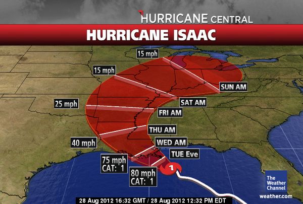
Named Storm Isaac has been a storm for the record books. It has not acted in a ‘normal’ manner since it first became a named storm in the Atlantic on August 21. This storm encountered many pockets of dry air to it’s north all along it’s track from the Atlantic, into the Caribbean and then finally into the Gulf of Mexico. Official agency forecasters predicted that Isaac would make ‘hurricane status’ for 5 days as it buffeted the west coast of Florida. It was only during it’s final 1-1/2 days before Louisiana landfall that it barely made Category 1 hurricane strength.

This storm had such a wide diameter and moved so slowly forward during it’s track across the northern Gulf of Mexico, that the rain, storm surge and wind effects caused as much devistation as what would be expected with a faster moving Category 2.

At this hour, the storm is still classified as a Tropical Storm and is making it’s way through the central parts of Louisiana and will be moving through Arkansas and into the Ohio Valley this weekend and into early this coming week. Additional flooding from very heavy rains can be expected in the south and central Midwest over the next several days.

We would like to thank those who sent feedback to us in many forms and we thank you all for allowing the Tropical Storm Research Center in Gulf Shores, Alabama, to be one of your sources of storm information, unofficially. Our staff of analysts and volunteer observers will continue to provide basic, unofficial Tropical Storm information, as we have since 2002.

For up to the minute official advisories and information, please visit the NHC website in Miami:

http://www.nhc.noaa.gov/

We are also providing an interactive Watch and Warning web link for persons who wish to get details on localized conditions:

http://www.nws.noaa.gov/largemap.php

=============================================

“THIS IS NOT AN OFFICIAL ADVISORY. These updates and advisories are based upon information from our own computer models, NOAA, Local Weather Data Centers, deep water Buoy Data, and other publicly available sources. FOR THE SAFETY OF YOUR PROPERTY AND PERSON, please refer to your Local, State, and Federal Authority updates for Official Advisories and Orders. For up to the minute advisories and official updates, it is essential that you monitor your local Emergency Government, NOAA and Local Media Broadcasts. Please do not make personal safety decisions based upon information presented here in this Unofficial Advisory.”

http://www.wootaah.blogspot.com

============================================

Named Storm Kirk

As previously stated, we will make mention of all NHC named storms. However, some storms will not be followed or reported on by the staff at TSRC.

Tropical Storm Kirk is in the central Atlantic… it may make hurricane status, but since it will be directed to the northeast AWAY from the US, we will not be reporting on this storm.

Hurricane Isaac Update Wednesday, August 29, 6:15 AM

As Hurricane Isaac continues to devastate the coastal areas of Alabama, Mississippi and Louisiana, we are asking today that you keep the residents of these areas in your prayers. This storm is a very slow mover and the storm’s effects will be felt for quite some time. We also would like to ask that you contact your local Red Cross Chapter to donate whatever cash that you can, so the Agency can continue to supply support to those families who are in need
.
The outer feeder bands of Isaac are producing very heavy rains and winds sustained at 40 MPH with gusts to over 60 MPH in parts of Coastal Alabama and Mississippi, with much higher rainfall totals and much higher winds in southeastern Louisiana.

For up to the minute official advisories and information, please visit the NHC website in Miami:

http://www.nhc.noaa.gov/

We are also providing an interactive Watch and Warning web link for persons who wish to get details on localized conditions:

http://www.nws.noaa.gov/largemap.php

=============================================

“THIS IS NOT AN OFFICIAL ADVISORY. These updates and advisories are based upon information from our own computer models, NOAA, Local Weather Data Centers, deep water Buoy Data, and other publicly available sources. FOR THE SAFETY OF YOUR PROPERTY AND PERSON, please refer to your Local, State, and Federal Authority updates for Official Advisories and Orders. For up to the minute advisories and official updates, it is essential that you monitor your local Emergency Government, NOAA and Local Media Broadcasts. Please do not make personal safety decisions based upon information presented here in this Unofficial Advisory.”

http://www.wootaah.blogspot.com

============================================

Hurricane Isaac

Isaac has attained hurricane status.  Isaac is now a Category One hurricane.  The forecast track remains along the mouth of the Mississippi River, and Isaac continues to bring 2 to 4 foot surge to the Gulf Shores area along with tropical storm force winds.  At this time, we do not see a major impact for our area, but with storm systems such as this, conditions can deteriorate rapidly.

Tropical Storm Isaac Unofficial Update 5 AM Tuesday August 28

Tropical Storm Isaac Update 5:00 AM Tuesday August 28 – and yes, it is STILL a Tropical Storm with a ragged center and lots of dry air to it’s north and northeast at this hour. That still may change, but indications are that the pressure is only going down slightly at this time.

All of the predominant tracking models this morning are placing the potential landfall just west of New Orleans in the overnight hours Tuesday into early Wednesday. The wind field intensity to the northeast of the center should be slightly less than what was anticipated yesterday by those models. But again… this will be a relatively long term event from northwestern Florida through coastal Alabama, Mississippi, Louisiana and as far west as eastern Texas.

Persons can expect high rainfall amounts, gusty tropical storm force winds out to 120+ miles from the center, lowland flooding and power interruptions.

For up to the minute official advisories and information, please visit the NHC website in Miami:

http://www.nhc.noaa.gov/

We are also providing an interactive Watch and Warning web link for persons who wish to get details on localized conditions:

http://www.nws.noaa.gov/largemap.php

=============================================

“THIS IS NOT AN OFFICIAL ADVISORY. These updates and advisories are based upon information from our own computer models, NOAA, Local Weather Data Centers, deep water Buoy Data, and other publicly available sources. FOR THE SAFETY OF YOUR PROPERTY AND PERSON, please refer to your Local, State, and Federal Authority updates for Official Advisories and Orders. For up to the minute advisories and official updates, it is essential that you monitor your local Emergency Government, NOAA and Local Media Broadcasts. Please do not make personal safety decisions based upon information presented here in this Unofficial Advisory.”

http://www.wootaah.blogspot.com

============================================

Isaac Still Expected to Reach Cat 2

TS Isaac is still expected to reach category two prior to landfall.  Isaac appears to have begun the long awaited strengthening process.  Movement appears to have shifted to more of a North-Northwest track. If this is not a “wobble” then landfall could be closer to the Alabama-Mississippi border.

Most models still suggest a potential landfall near New Orleans.  If this verifies, here in Gulf Shores, we can expect tropical storm force winds, flooding, and isolated tornadoes.  As Isaac continues to strengthen, both amateur and professional trackers should get a better feel for his “final destination”.