Named Storm Ernesto – Final US Update

Named Storm Ernesto – Update 05:30 AM CDT 07 August 2012.

Ernesto is being steered by the westerly flow of an upper level high pressure area. The storm may make Hurricane status by the time it makes it’s first landfall near Belize on Wednesday. The storm will cross the Yucatan Peninsula and continue westbound over the southern Gulf of Mexico and make a second landfall south of Tampico, Mexico, on Friday. Since this storm no longer poses a threat to the US Gulf Coast, this will be our final Ernesto update. However, persons in Mexico should monitor this storm’s progress.

For up to the minute official advisories and information, please visit the NHC website in Miami:

http://www.nhc.noaa.gov/

We are also providing an interactive Watch and Warning web link for persons who wish to get details on localized conditions:

http://www.nws.noaa.gov/largemap.php

=============================================

“THIS IS NOT AN OFFICIAL ADVISORY. These updates and advisories are based upon information from our own computer models, NOAA, Local Weather Data Centers, deep water Buoy Data, and other publicly available sources. FOR THE SAFETY OF YOUR PROPERTY AND PERSON, please refer to your Local, State, and Federal Authority updates for Official Advisories and Orders. For up to the minute advisories and official updates, it is essential that you monitor your local Emergency Government, NOAA and Local Media Broadcasts. Please do not make personal safety decisions based upon information presented here in this Unofficial Advisory.”

http://www.wootaah.blogspot.com

============================================

Tropical Storm Ernesto Update Saturday, Aug. 04

Tropical Storm Ernesto update – Saturday August 04, 08:30 Hrs EDT.

Tropical storm Ernesto continues to strengthen and continies to move to the west northwest in the Caribbean. Sustained winds are just above 60 MPH with gusting to over 75 MPH. Projections are that Ernesto will be upgraded to Hurricane status over the weekend and will be affecting southern Hispaniola, Jamaica and the Cayman Islands. As this storm feeds on the warm Caribbean waters, it’s strength will increase significantly. The tracking models are showing a Gulf of Mexico involvement late Wednesday, August 8 into early Thursday, August 9. Once this storm enters the Gulf of Mexico, where the water temperatures are higher than average, the storm will most likely internsify. Tracking models past Wednesday, August 8, are inconclusive at this time. However, persons in all US Gulf Coast States should be monitoring the progress of this storm carefully.

We are also tracking Tropical Storm Florence, but this storm will be running in to significant upper level shear which will prevent it from developing initially. We will only report on Tropical Storm Florence if it takes a track that would allow it to strengthen.

For up to the minute official advisories and information, please visit the NHC website in Miami:

http://www.nhc.noaa.gov/

We are also providing an interactive Watch and Warning web link for persons who wish to get details on localized conditions:

http://www.nws.noaa.gov/largemap.php

=============================================

“THIS IS NOT AN OFFICIAL ADVISORY. These updates and advisories are based upon information from our own computer models, NOAA, Local Weather Data Centers, deep water Buoy Data, and other publicly available sources. FOR THE SAFETY OF YOUR PROPERTY AND PERSON, please refer to your Local, State, and Federal Authority updates for Official Advisories and Orders. For up to the minute advisories and official updates, it is essential that you monitor your local Emergency Government, NOAA and Local Media Broadcasts. Please do not make personal safety decisions based upon information presented here in this Unofficial Advisory.”

http://www.wootaah.blogspot.com

============================================

Named Storm Ernesto

Tropical Storm Ernesto formed out of Tropical Depression # 5 today – 24 hours earlier than anticipated. This storm is intensifying, even though it is still over moderately cool waters in the west central Atlantic. This storm will be crossing into the Caribbean Friday morning, August 03, and will be feeding off of the warm Caribbean waters. Several computer models are showing hurricane status by late Sunday, August 05, just south of Jamaica and additional strengthening by early Monday morning, August 06. We are watching this developing storm carefully and will post unofficial updates as conditions change. Persons along the Florida coast as well as persons along the Gulf Coast should be monitoring this storm through your local media and the National Hurricane Center.

For up to the minute official advisories and information, please visit the NHC website in Miami:

http://www.nhc.noaa.gov/

We are also providing an interactive Watch and Warning web link for persons who wish to get details on localized conditions:

http://www.nws.noaa.gov/largemap.php

=============================================

“THIS IS NOT AN OFFICIAL ADVISORY. These updates and advisories are based upon information from our own computer models, NOAA, Local Weather Data Centers, deep water Buoy Data, and other publicly available sources. FOR THE SAFETY OF YOUR PROPERTY AND PERSON, please refer to your Local, State, and Federal Authority updates for Official Advisories and Orders. For up to the minute advisories and official updates, it is essential that you monitor your local Emergency Government, NOAA and Local Media Broadcasts. Please do not make personal safety decisions based upon information presented here in this Unofficial Advisory.”

http://www.wootaah.blogspot.com

============================================
Tropical Update August 02

The 2012 Tropical Storm Season has been very tame thus far, however, as we get into the peak months for storm development, that may change. We are currently watching Tropical Depression # 5. The storm center is located approximately 500 miles east of the Windward Islands and is moving westerly at approximately 17 MPH. As the storm center gets in to the warmer Caribbean waters by late Friday night, the storm will be increasing in intensity and may become Tropical Storm Ernesto. As this storm develops, we will post unofficial updates as warranted.

For up to the minute official advisories and information, please visit the NHC website in Miami:

http://www.nhc.noaa.gov/

We are also providing an interactive Watch and Warning web link for persons who wish to get details on localized conditions:

http://www.nws.noaa.gov/largemap.php

=============================================

“THIS IS NOT AN OFFICIAL ADVISORY. These updates and advisories are based upon information from our own computer models, NOAA, Local Weather Data Centers, deep water Buoy Data, and other publicly available sources. FOR THE SAFETY OF YOUR PROPERTY AND PERSON, please refer to your Local, State, and Federal Authority updates for Official Advisories and Orders. For up to the minute advisories and official updates, it is essential that you monitor your local Emergency Government, NOAA and Local Media Broadcasts. Please do not make personal safety decisions based upon information presented here in this Unofficial Advisory.”

http://www.wootaah.blogspot.com

============================================

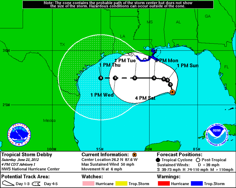
Tropical Storm Debby Update 25 June – 6 AM CDT

Tropical Storm Debby Update 25 June. Since the trough from the high pressure area completely missed picking up the storm system, it is now just sitting in the Gulf, nearly stationary, hammering western and northwestern Florida with huge rainfall totals, beach errosion and high surf. Since there are no weather systems near by to steer the storm, it will slowly drift around the north central Gulf for a few days and finally weaken to a tropical depression (as projected at this time.)

For up to the minute official advisories and information, please visit the NHC website in Miami:

http://www.nhc.noaa.gov/

We are also providing an interactive Watch and Warning web link for persons who wish to get details on localized conditions:

http://www.nws.noaa.gov/largemap.php

=============================================

“THIS IS NOT AN OFFICIAL ADVISORY. These updates and advisories are based upon information from our own computer models, NOAA, Local Weather Data Centers, deep water Buoy Data, and other publicly available sources. FOR THE SAFETY OF YOUR PROPERTY AND PERSON, please refer to your Local, State, and Federal Authority updates for Official Advisories and Orders. For up to the minute advisories and official updates, it is essential that you monitor your local Emergency Government, NOAA and Local Media Broadcasts. Please do not make personal safety decisions based upon information presented here in this Unofficial Advisory.”

http://www.wootaah.blogspot.com

============================================

Tropical Storm Debby

Tropical Storm Debby formed out of the remnants of an easten Pacific storm as it crossed Mexico into the Gulf. This storm will be moving generally west along a high pressure trough. However, the majority of the rains associated wit this storm will be affecting persons from northwestern Florida to east central Texas over the next 5 to 7 days. Persons who live in the Gulf coastal areas should be watching this storm’s progress.

For up to the minute official advisories and information, please visit the NHC website in Miami:

http://www.nhc.noaa.gov/

We are also providing an interactive Watch and Warning web link for persons who wish to get details on localized conditions:

http://www.nws.noaa.gov/largemap.php

=============================================

“THIS IS NOT AN OFFICIAL ADVISORY. These updates and advisories are based upon information from our own computer models, NOAA, Local Weather Data Centers, deep water Buoy Data, and other publicly available sources. FOR THE SAFETY OF YOUR PROPERTY AND PERSON, please refer to your Local, State, and Federal Authority updates for Official Advisories and Orders. For up to the minute advisories and official updates, it is essential that you monitor your local Emergency Government, NOAA and Local Media Broadcasts. Please do not make personal safety decisions based upon information presented here in this Unofficial Advisory.”

http://www.wootaah.blogspot.com

============================================

PLEASE do not post replies in Named Storm Threads. Thank You.

Gulf of Mexico Storm Developing and Concerns, June 22

For those persons who live in the Gulf Coast States: You may already be looking carefully at the developing southern Gulf of Mexico storm. This has the potential to drench southwestern and central Florida with up to 20 inches of rain in places. However, it all depends upon the TIMING of a trough of low pressure entering the general area as to where this storm will be steered. If the trough fails to pick up the storm, it may go north or even westerly instead of into Florida’s Gulf Coast. Please monitor your local weather stations and media for local updates.

For up to the minute official advisories and information, please visit the NHC website in Miami:

http://www.nhc.noaa.gov/

We are also providing an interactive Watch and Warning web link for persons who wish to get details on localized conditions:

http://www.nws.noaa.gov/largemap.php

=============================================

“THIS IS NOT AN OFFICIAL ADVISORY. These updates and advisories are based upon information from our own computer models, NOAA, Local Weather Data Centers, deep water Buoy Data, and other publicly available sources. FOR THE SAFETY OF YOUR PROPERTY AND PERSON, please refer to your Local, State, and Federal Authority updates for Official Advisories and Orders. For up to the minute advisories and official updates, it is essential that you monitor your local Emergency Government, NOAA and Local Media Broadcasts. Please do not make personal safety decisions based upon information presented here in this Unofficial Advisory.”

http://www.wootaah.blogspot.com

============================================

Tropical Storm Chris PLUS Gulf Info

Tropical Storm Chris formed Wednesday in the central Atlantic. It’s path will take it easterly and it poses no threat to the United States.

However, we are watching a strong low pressure area in norhern Mexico that is going to intensify and may become a tRopical Depression and storm within 36 hours. if you live in a Gulf of Mexico State, please monitor your local weather broadcasts for updates as well as here for periodic unofficial advisories.

For up to the minute official advisories and information, please visit the NHC website in Miami:

http://www.nhc.noaa.gov/

We are also providing an interactive Watch and Warning web link for persons who wish to get details on localized conditions:

http://www.nws.noaa.gov/largemap.php

=============================================

“THIS IS NOT AN OFFICIAL ADVISORY. These updates and advisories are based upon information from our own computer models, NOAA, Local Weather Data Centers, deep water Buoy Data, and other publicly available sources. FOR THE SAFETY OF YOUR PROPERTY AND PERSON, please refer to your Local, State, and Federal Authority updates for Official Advisories and Orders. For up to the minute advisories and official updates, it is essential that you monitor your local Emergency Government, NOAA and Local Media Broadcasts. Please do not make personal safety decisions based upon information presented here in this Unofficial Advisory.”

http://www.wootaah.blogspot.com

============================================

PLEASE do not post replies in Named Storm Threads. Thank You.