
Please review Comment # 1 under Acral’s Post – “Models are Going Crazy” – just below this memo. Thank you and be safe!!
Models are going crazy
![]()
With a 700 + mile cone, the NHC forecast is mired in uncertainty about T.S. Fay. Her maximum sustained winds are at 60 MPH, and is slowly moving westward dropping massive amounts of rain. Click on the image to enlarge it.
The graphic illustrates the confusion in the models, and strongly indicates that our area will feel the effects of Fay after all.
Fay is is bringing rain

TS Fay’s westward shift appears to have begun. Thankfully, Fay will not be over water for much of her future. Unfortunately, she appears to be headed our way with copius amounts of rain. Flooding, especially in areas such as Santa Rosa County (FL) Escambia County (FL), and Baldwin County (AL) reamins a very real threat.
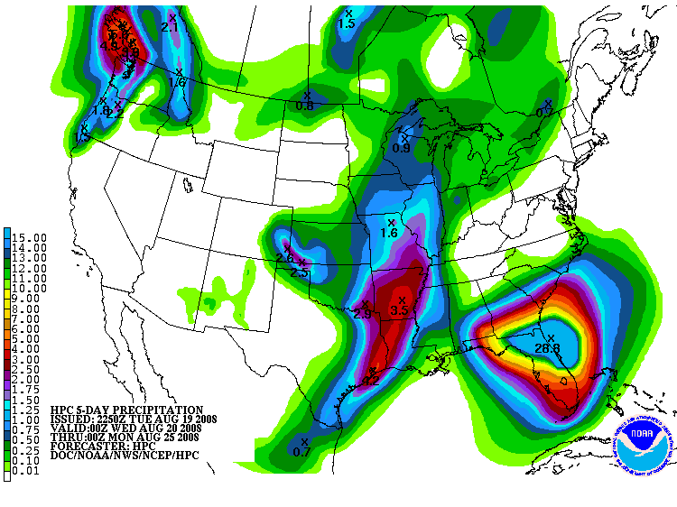
Rainfall amounts could range from 10 inches to over 18 inches. For our area, should the models verify, I would expect 6-8 inches of rain.
Invest 94L is marching to the west, but has shear and the SAL to contend with over the next few days. Rapid development is not expected, and there is a good chance that the shear and dry air will preclude any development.
The models are still nuts
Some data as well as imagery suggest that Fay may be stalling, and if so, rainfall could be measured in feet as opposed to inches.
It is starting to appear that our area may very well feel the effects of Fay, yet not in the manner I had thought. This is a very strange storm. This afternoon she appeared to be intensifying, but starting to look pretty rough at the time of this writing. On several sites, the thought from both amatuers such as myself and professional climatologists and meteorologists is “Fay go away and give us something we can make sense of.
Tropical Storm Fay – Second Florida Landfall, August 19
This is being posted for any persons in Baldwin County, Mobile County or Escambia County (FL) who may have interests or family in the Marco Island, Florida area: Please review Comment # 1 in Acral’s – “We Have Noodles” post below this one. Thank you.
We have Noodles
![]()
Fay is still driving the models nuts, and I am proud to say that I WAS WRONG. The High is shoving Fay to the east, yet the models are bound and determined shove her back west even over north Alabama.
She has maintained her northerly track and does not have much potential in the way of intensification as long as she stays on her current path. A plus can be drawn in that she holds the potential to bring much needed relief to draught areas.
Fay is a killer. She is not done yet. Stay safe and vigilant, but for our area, the immediate threat is all but over.
Shear and Highs
Fay has both, some wind shear and a High pressure system that is trying to keep her timid and push her to the east. The GFDL and GFS models toss her over the Florida Peninsula whereas the BAMS and NOGAPS bring her to our neck of the woods.
She appears to be showing a straight northerly movement which is very good for our area, and Florida in that her time over water will be significantly reduced. The key will be over the next 36 hours, to see where she takes aim. She remains a small storm, and appears to be showing signs of intensifying, but I don’t think she will become a major hurricane before landfall based on current data.
All of that can change in a matter of hours, but for now, our set up is looking better and better for us.
Fay has trouble

The mountainous regions of Cuba may destroy Fay, but I doubt it.
The bath water we have discussed is still there and Fay is growing. She has an impressive anti-cyclone with her which allows her to vent energy as she creeps westward. Our cone of impact is edging towards the Florida panhandle, parts of Mississippi and Alabama should watch this system.
Fay has been stubborn and is determined to make a name for herself. She still has some obstacles to overcome, and that will be the telling. Another update inside of 12 hours.
Tropical Cyclone Fay

According to internal reports from the U.S. Navy and the NHC, Tropical Cyclone Fay has formed. We expect an official 5-day cone at the 5pm EDT report from the National Hurricane Center.
Models continue to suggest that Fay will emerge into the Gulf of Mexico with the potential to become a major hurricane. At the early juncture, wild speculation could put Fay anywhere from Mississippi to the Florida coast line. New models are being ran, and I’ll have more information later today.
The NHC headers are:
293
WHXX01 KWBC 152000
CHGHUR
TROPICAL CYCLONE GUIDANCE MESSAGE
NWS TPC/NATIONAL HURRICANE CENTER MIAMI FL
2000 UTC FRI AUG 15 2008
DISCLAIMER…NUMERICAL MODELS ARE SUBJECT TO LARGE ERRORS.
PLEASE REFER TO NHC OFFICIAL FORECASTS FOR TROPICAL CYCLONE
AND SUBTROPICAL CYCLONE INFORMATION.
ATLANTIC OBJECTIVE AIDS FOR
TROPICAL CYCLONE FAY (AL062008) 20080815 1800 UTC
Please Welcome Pastor Gary
With over 20 years in Law Enforcement and a Doctorate in Theology and Divinity Studies, Pastor Gary’s impressive credentials lend themselves to storm preparation and analysis. Gary is an avid and accomplished spotter, running his models in conjunction with the public models that we use to provide timely and accurate information on this blog. He is also a Certified First Responder and Chaplin, providing vital aid in times of need.
His goals are the same, to ensure the protection of life and property, and provide assistance to those affected by the devasting physical and emotional trauma that follows a significant weather event. Please join me in welcoming Pastor Gary, as his experience and insight will prove invaluable before, during, and after a major storm.
This blog remains part of a project and plan that we (Gary and I) have been striving towards for over 3 years, first on various forums, and now, at long last, in a centralized location. Gary and I have worked closely together on weather patterns and severe events for over 3 years, and his expertise has proven time and time again to be invaluable.
On a personal note, Gary, I am proud to have you as a member of this team. For several years I have respected and appreciated your input, guidance, and friendship. Welcome aboard, my friend!
-=-=-=-=-=-=-=-=-=-=-

The graphic to the above-left from http://www.weatherunderground.com/ illustrates the high Sea Surface Temperatures (SST’s) ahead of this Invest. This system remains a very serious potential threat, and is still expected to develop. For now, it is a small, compact system, which, as history demonstrates, could rapidly develop in a short time.