Dual Threat

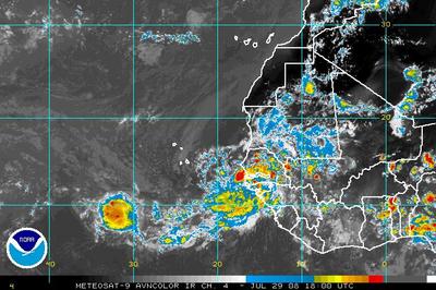
This graphic from the NOAA National Hurricane Center illustrates the threat areas we have been watching. Invests are good candidates with Invest 92L (the are closest to United States interest) showing a strong likelihood for development.
Some questions have been raised at why the predictions have increased the number of storms this season. The answer is that conditions in the Atlantic have become much more favorable for development: low wind shear, warm waters, and a lessening of the Saharan Air Layer (SAL). Additionally, there are no signs of a La Nina event, which would hamper storm formation as well. Over the next 48 hours, these two areas of tropical disturbance should be monitored.

The long range GFDL 12z model run presents the following graphic. The 2pm EDT discussion from the National Hurricane Center is as follows:
-=-=-=-=-
DATA FROM NOAA BUOYS INDICATE THAT A BROAD AREA OF LOW PRESSURE ASSOCIATED WITH A TROPICAL WAVE IS LOCATED ABOUT 550 MILES EAST OFTHE LESSER ANTILLES. CLOUDINESS AND SHOWERS ASSOCIATED WITH THISLOW HAVE CHANGED LITTLE IN ORGANIZATION SINCE THIS MORNING. ENVIRONMENTAL CONDITIONS APPEAR CONDUCIVE FOR A TROPICAL DEPRESSIONTO FORM DURING THE NEXT DAY OR SO AS THE SYSTEM MOVESWEST-NORTHWESTWARD AT 10 TO 15 MPH. AN AIR FORCE RESERVE HURRICANEHUNTER AIRCRAFT IS CURRENTLY ENROUTE TO INVESTIGATE THE AREA.

Remote Data Backups

92L and 93L

Invest 92L is followed by Invest 93L, and a vigorous wave coming off the coast of Africa threatens to become a thrid potential tropical system.

Invests 92L and 93L are both expected to develop and both will probably threaten the Lesser Antilles.

Invest 92L – One to Watch

Invest 92 L has formed in the central Atlantic. Virtually all of the models bring this storm to Tropical Status within the next few days, with the SHIPS model being particularly aggressive in bringing this Invest to Hurricane strength in 3 days. The GFL is forecasting a tropical storm in that 72 hour window.

Shear and overall conditions are favorable for development, and the Lesser Antilles should experience tropical storm conditions within the next several days. The forecasted track could place this storm in or near the Gulf of Mexico, making it the first real contender for our area this season.
Elsewhere, another wave is expected to form/move off the coast of Africa, and could be one to watch as well.
For the Gulf Shores/Orange Beach area, this is the “meat” of the season, and the next seven to ten days should prove to be interesting. As always, these potential systems are far to weak and too far away to make any guesses about how or where they will end up, however, for the next couple of months, our area could find itself “under the gun” a time or two.

Hurricane Predictions Upgraded

Colorado State upgrades expected hurricane season, Now forecasting 17 named storms; 5 intense hurricanes

Even though the Florida peninsula did suffer the ravages of 3 major landfalling hurricanes during 2004 & 2005 (Charley, Jeanne, Wilma; also, Frances in 2004 [960 mb/ 90-95 kts] was very close to cat-3 intensity at landfall)…….this area of America home to over 10 million residents is still FAR BELOW normal when it comes to major hurricane direct hits since 1965 (only 4 category 3 or higher hurricane landfalls during the 42 year period of record 1966-2007). Historically, the Florida peninsula is struck by a major landfalling hurricane once every four (4) years (climatological period of record 1851-2000).”

For the next few days, it looks as if we will have a slight break in the action, as there are no systems showing any real signs of development at this time.

TS Edouard Intensifying

Tropical Storm Edouard is strengthening from the benefit of reduced shear, making it entirely likely to reach land Tuesday as a Catagory One hurricane. Landfall is still estimated at the TX/LA border, but landfall could be a bit to the east in Lousiana if what may happen been a slight northerly “wobble” is a shift to the north.

Elsewhere, there are no immediate threats to land for the U.S. at this time and no significant development is expected over the next few days.

Tropical Storm Edouard

TS Edouard formed today in the Gulf of Mexico. Most models predict a hit around Tuesday for the Texas coast. Edouard should make landfall as a tropical storm, however, it is not unthinkable that Edouard coult attain hurricane status prior to landfall.
Elsewhere in the Atlantic Basin, there are two other areas of disturbed weather that bear watching but significant development is not expected at this time.

Quiet after some activity

The tropics are fairly quiet after a couple of interesting weeks. None of the developments over the past month have posed a direct threat to the Gulf Shores/Orange Beach area. Currently, as evidenced below, there is one Invest (area of interest) moving off the coast of Africa.

The tropical wave is disorganized, but does show some potential for development, albeit, assuming it does develop, it would probably become a “fish”. (This means that it should meander harmlessly around the Atlantic much like Hurricane Bertha and T.S. Cristobal did in the north/central Atlantic Basin. Invest 98L (depicted above) has an uphill battle ahead of it as it traverses the Atlantic with cooler water temperatures and the dry air from the Saharan dust layer.

If the month of July is any indication, then as we enter the “meat” of the 2008 hurricane season, we should be looking at increased activity through August and September.

Remote Data Backups

More to our immediate concern is the possibility of localized severe storms and flash flooding over the next few days. The primary threat of severe weather should be well to the north of us.

Severe Weather and Upgraded Hurricane ‘cast

Today, Friday – April 4, 2008 marks a potential severe weather outbreak. At the time of this writing, 9:14am EDT numerous Tornado and Severe Thunderstorm warnings are in effect. This tornado struck Little Rock AR earler, causing extensive damage to cars, planes, and structural damage.

Our area should be experiencing rain and the possibility of severe weather later this evening, beginning around 5pm/7pm EDT.
Dr. Gray has suggested that he may increase his hurricane forecast from 13/7 (13 named storms, 7 hurricanes) as the Atlantic SST’s are warmer much as they were 2004 and 2005. While no one anticipates a whirlwind season like ’05, chances are we will see more activity in the Gulf of Mexico than we have in the past few years.

Sub-Tropical Storm Olga

ST Olga has formed, primarily posing a threat to the Bahamas, possibly including Puerto Rico. Only one of the models has it making a brief entry to the Gulf of Mexico.

While unusual, it is not impossible to have a storm form during this time of year, even though Hurricane Season “officially” ended at the end of November.

Tropical Storm Karen

Tropical Storm Karen has formed in the central Atlantic. While most models have the system intensifying to hurricane strength, at this point Karen does not appear to be a threat to any land masses. There is a chance that Karen could miss the trough that is expected to make her recurve north, and if that unlikely event occurs, Karen could pose a threat to the U.S. East Coast.

However, Karen seems perfectly content posing a threat to only the rogue flying fish or two.

The shear has lessened in the Gulf of Mexico, and we should see a tropical depression or tropical storm form from the area of disturbed weather in the western GoM, and that system is expected to push into Mexico.

Invest 97L continues to churn towards the Lesser Antilles, and should be monitored as conditions are ripe for development.